How Underground Utility Mapping Can Prevent Costly Construction Delays


Understanding Underground Utility Mapping
In the realm of construction, one of the most critical yet often overlooked elements is the presence of underground utilities. From water lines and electrical conduits to gas pipes and telecommunications cables, these hidden infrastructures form a complex network beneath our feet. Underground utility mapping is a crucial process that involves identifying and documenting these subsurface utilities to ensure safe and efficient construction projects.
Accurate utility mapping not only provides a comprehensive layout of underground infrastructures but also helps in avoiding accidental damages during excavation. Such damages can lead to significant project delays and increased costs.
The Importance of Accurate Mapping
Constructing without proper utility mapping is akin to navigating through a maze blindfolded. It exposes projects to the risk of hitting unknown utility lines, which can result in service disruptions, safety hazards, and costly repairs. To prevent such mishaps, it is essential to engage in thorough utility mapping before any ground-breaking activities.
Accurate utility maps ensure that construction teams are aware of all existing utilities, allowing them to plan their work around these obstacles. This foresight minimizes the risk of accidents and ensures that construction proceeds smoothly.

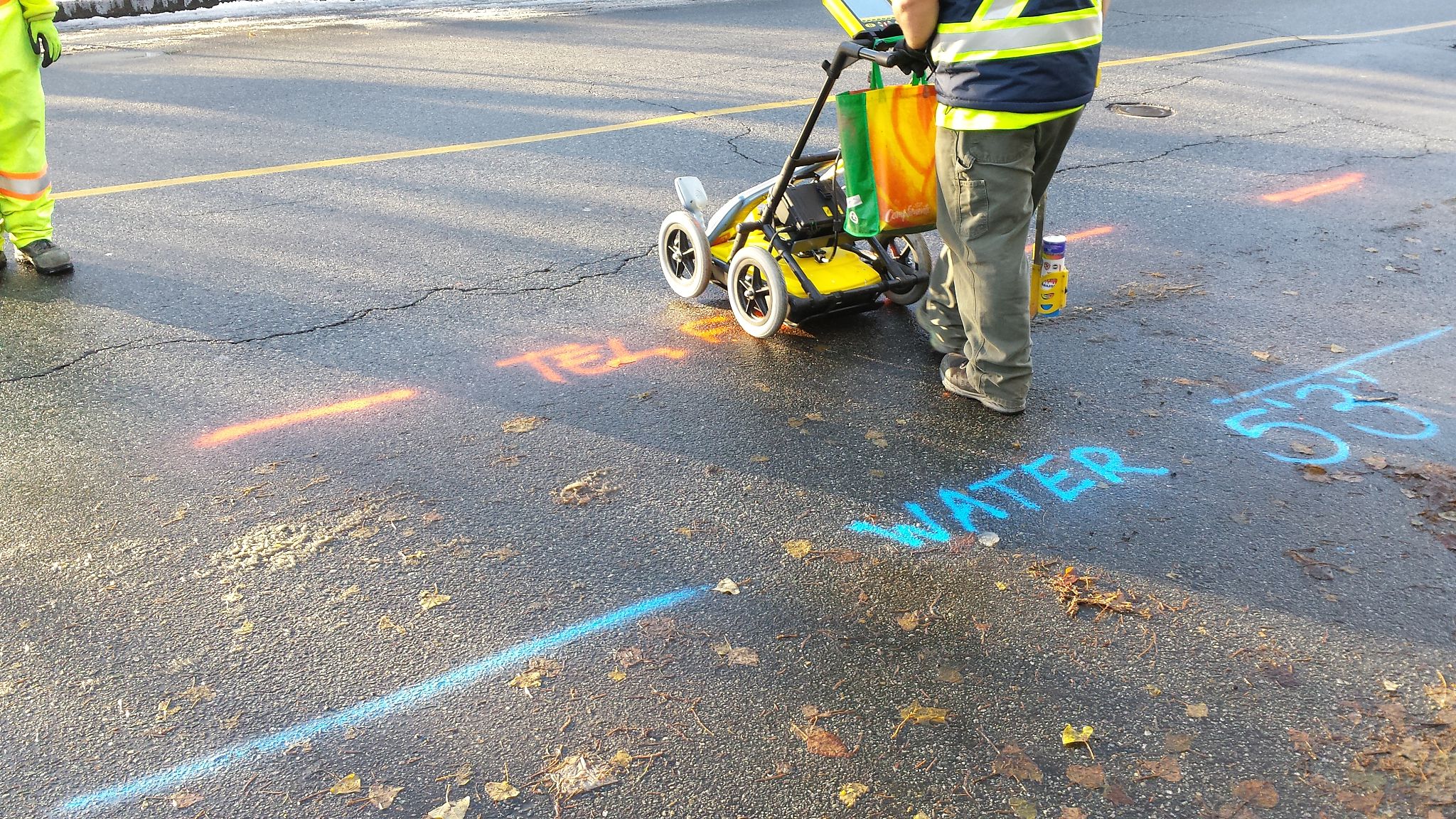
Techniques Used in Utility Mapping
A variety of advanced techniques are employed in underground utility mapping. Some common methods include:
- Ground Penetrating Radar (GPR): This technique uses radar pulses to image the subsurface, providing detailed information about the location and depth of utilities.
- Electromagnetic Locating: This method detects the electromagnetic fields emitted by underground cables and pipes, allowing for precise mapping.
- Acoustic Location: By using sound waves, this technique helps in identifying the presence and alignment of utility lines.
Preventing Costly Delays
Construction delays can be a significant financial burden. They not only increase labor costs but can also lead to penalties for late project delivery. Utility mapping helps prevent such delays by ensuring that construction activities proceed without unexpected interruptions.
When a project manager is equipped with detailed utility maps, they can make informed decisions about excavation and construction methods. This proactive approach reduces the likelihood of encountering unforeseen obstacles and minimizes downtime.

The Role of Technology in Utility Mapping
The integration of technology in utility mapping has greatly enhanced accuracy and efficiency. Geographic Information Systems (GIS) and Building Information Modeling (BIM) are increasingly being used to create comprehensive digital maps that can be easily accessed and updated by construction teams.
These digital tools allow for real-time collaboration among different stakeholders, ensuring that everyone involved in the project is on the same page. By leveraging technology, construction companies can streamline their operations and avoid costly setbacks.
Conclusion: A Worthwhile Investment
Investing in underground utility mapping is a decision that pays dividends in the form of reduced risks, fewer delays, and controlled costs. By prioritizing accurate mapping, construction companies can ensure the safety of their workers, protect existing infrastructure, and deliver projects on time.
Ultimately, underground utility mapping is not just a precautionary measure—it's a strategic approach that supports successful project outcomes. As construction projects continue to grow in complexity, the importance of utility mapping cannot be overstated.