
What is Turnkey Locating? A Contractor's Guide
Calling 811 is a non-negotiable first step, but it’s not the whole story. Public locators are only responsible for marking utilities up to the meter. Everything beyond that—the private power lines to your parking lot lights, the fiber optic cables between buildings, the forgotten irrigation systems—is your responsibility. Relying solely on a public locate leaves your project vulnerable to dangerous and costly strikes. A comprehensive turnkey locating service is designed to fill these critical gaps. By using advanced technology like GPR and EM detection, we find what 811 misses, giving you a complete and accurate picture of your entire site, not just the public right-of-way.
Key Takeaways
- Streamline Coordination with a Single Point of Contact: A turnkey approach combines all locating services—GPR, EM, and mapping—into one seamless process, freeing you from juggling multiple contractors and preventing communication breakdowns.
- Prevent Costly Surprises Before You Dig: Go beyond the basic 811 call to find what it misses: private utilities, non-metallic lines, and undocumented infrastructure. This proactive step is the best way to protect your crew, budget, and schedule from unexpected strikes.
- Receive Clear, Engineer-Ready Data: A professional locate delivers more than just field markings. You get precise, usable digital files like CAD and GIS maps that integrate directly into your project plans, ensuring accuracy from design through excavation.
What Is Turnkey Utility Locating?
If you’ve ever felt bogged down coordinating multiple contractors just to clear a site for excavation, you already understand the need for a simpler process. Turnkey utility locating is the answer. Think of it as a comprehensive, end-to-end service that handles every step of identifying and mapping underground utilities for you. Instead of juggling different teams for GPR scanning, EM locating, and data mapping, you get one expert crew that manages the entire workflow from start to finish.
This approach is designed to remove the logistical headaches and bureaucratic delays that can stall a project. A turnkey provider takes full ownership of the locating process, delivering clear, actionable data you can use immediately. For general contractors, facility managers, and engineers, this means you can focus on your core responsibilities—like planning soil borings or trenching—without getting sidetracked. The goal is to give you a complete, field-ready picture of the subsurface with a single point of contact.
How Utility Locating Has Evolved
In the past, locating utilities was often a fragmented and frustrating process. You might have had to deal with public services for one part, then hire a separate specialist for private lines, and maybe another for mapping. This old model was inefficient and left too much room for error and miscommunication. The industry has since shifted toward integrated turnkey solutions that put the client’s needs first. This evolution frees you from getting tangled in red tape and lengthy coordination efforts. By handing the entire process over to a single, trusted partner, you minimize your direct involvement and can trust that the job will be done right, reducing stress and keeping your project moving forward.
Key Components of a Turnkey Service
A true turnkey service is built on a foundation of integrated technology and a streamlined workflow. It’s not just about having the right equipment; it’s about how that equipment is used to create a seamless process. Key components include using multiple detection methods, like Ground Penetrating Radar (GPR) and Electromagnetic (EM) locators, to find what 811 misses. This technological integration allows for more accurate and timely utility mapping. The data collected in the field is then processed and delivered in a clear, usable format, such as a CAD-ready file. This comprehensive approach ensures you get a complete picture of the subsurface without delays, enhancing project management from day one.
Why a Professional Locate Matters for Your Project
Beyond just meeting legal requirements, a professional utility locate is one of the smartest investments you can make in your project's success. It’s about shifting from a reactive approach—dealing with problems as they happen—to a proactive one where you have the data you need before the first shovel hits the ground. This foresight protects your crew, your schedule, and your bottom line by providing a clear, comprehensive picture of the subsurface environment. When you know exactly what’s buried on your site, you can plan with confidence and avoid the costly surprises that derail even the best-laid plans.
Reduce On-Site Risk and Improve Safety
Every excavation carries inherent risks, but hitting an unknown utility line can turn a routine job into a crisis. A comprehensive locate identifies gas, electric, water, and communication lines, removing the dangerous guesswork that leads to accidents. By providing a complete package of subsurface data tailored to your site, a turnkey service gives your crew a clear and accurate map to work from. This significantly reduces the chance of errors and creates a safer working environment for everyone on site. It’s the most effective way to prevent catastrophic utility strikes, protecting both your team and the public from serious harm.
Keep Your Project on Time and on Budget
Nothing derails a project faster than an unexpected utility strike. The immediate aftermath involves emergency repairs, potential fines, and costly crew downtime. A professional locate helps you avoid these budget-breaking surprises. A turnkey solution is especially effective because it streamlines the entire process, freeing you from the bureaucratic complications and delays of coordinating with multiple parties. Instead of waiting on separate public and private locates, you get one comprehensive survey that keeps your project moving forward. This proactive step is critical for maintaining your schedule and preventing the unforeseen expenses that can quickly eat into your profit margin.
Get Clear, Actionable Records
Vague field markings and hard-to-read sketches aren’t enough to guide a modern construction project. A professional locating service integrates advanced technology to deliver precise, usable data. You receive clear, digital maps and CAD-ready files that your engineers and field crews can use immediately. This level of detail is essential for planning bore paths, designing foundations, or trenching for new infrastructure. By providing clear, actionable records, a turnkey subsurface utility mapping service ensures that everyone on your team is working from the same accurate information, which increases efficiency and reduces the risk of costly misinterpretations on the job.
The Advantage of a Single Point of Contact
When you’re managing a complex project, clear communication is everything. Juggling calls between the 811 service, surveyors, and separate private locators can lead to confusion and crossed wires. A turnkey solution provides a single point of contact for all your subsurface questions. This direct line to an expert team enhances coordination and makes it easier to get answers when you need them. Whether you have a question about the initial survey or need clarification on the final report, you know exactly who to call. This streamlined communication helps your project run more smoothly and ensures that critical information doesn't get lost in the shuffle.
The Technology Behind Accurate Locates
Getting a clear picture of what’s underground isn’t about guesswork or a single magic wand. It’s a science that relies on a combination of advanced technologies. Different site conditions and utility types require different tools, and a professional crew knows exactly which ones to use to build a complete and accurate map. While one method might be perfect for finding a metal water line, it could completely miss a fiber optic cable right next to it. Relying on a single piece of tech is a recipe for incomplete data and, ultimately, a risky excavation.
That’s why modern utility locating services don’t depend on just one piece of equipment. Instead, they layer data from multiple sources to cross-reference findings and fill in the gaps. By combining methods like Ground Penetrating Radar (GPR) and Electromagnetic (EM) detection, technicians can identify a wide range of materials, from conductive pipes to non-metallic conduits. This information is then captured with high-precision GPS, turning temporary paint marks into a permanent, reliable digital record for your project team. This multi-technology approach is what separates a basic locate from a truly comprehensive one, giving you the confidence you need before breaking ground.
Ground Penetrating Radar (GPR)
Think of Ground Penetrating Radar (GPR) as a high-tech fish finder for the ground. This equipment sends pulses of radio waves into the subsurface and reads the signals that bounce back. When the waves encounter a change in material—like the edge of a pipe, a void, or a buried tank—it creates a distinct reflection. This allows technicians to create a visual cross-section of what’s below the surface. The biggest advantage of GPR technology is its ability to detect non-metallic objects, such as PVC pipes, concrete structures, and fiber optic lines, which are invisible to other methods. It’s an essential tool for getting a complete picture of a complex site.
Electromagnetic (EM) Detection
Electromagnetic (EM) detection is the go-to method for finding conductive metallic utilities. The process works by sending a specific radio frequency through a transmitter, which creates an electromagnetic field around a target line like a copper wire or steel pipe. A handheld receiver is then used to trace this signal from above ground, pinpointing the utility’s location and approximate depth. While it’s incredibly effective for its intended purpose, EM detection can’t locate non-conductive materials. That’s why it’s almost always used in tandem with GPR to ensure nothing is missed. Together, they provide a powerful one-two punch for comprehensive utility detection.
GPS and GIS Integration
Finding a utility is one thing; documenting its exact location for future use is another. This is where GPS and GIS integration comes in. Once a utility is located in the field, technicians use survey-grade GPS equipment to capture its precise geographic coordinates. This data is far more accurate than what you’d get from a standard smartphone. That location data is then imported into a Geographic Information System (GIS), which is a powerful mapping software. This process transforms field markings into a permanent, layered digital map, creating an actionable record your engineers and designers can use for planning. It’s how we deliver clean, engineer-ready results.
Modern Subsurface Mapping
Modern subsurface mapping is all about data fusion. It’s the practice of combining information from GPR, EM locators, GPS data, and existing site plans to create a single, comprehensive view of the underground environment. Instead of relying on one technology’s strengths, this approach uses multiple methods to confirm findings and eliminate blind spots. The final product isn’t just a collection of points on a map; it’s a detailed subsurface utility map that shows the horizontal and vertical position of buried infrastructure. This integrated model gives your team the confidence to excavate, trench, or bore without hitting costly or dangerous surprises.
How the Turnkey Locating Process Works
A true turnkey locating service isn’t just about showing up and waving a wand over the ground. It’s a structured, multi-step process designed to deliver reliable data you can build on. From the first call to the final report, every stage is built around accuracy, efficiency, and clear communication. This systematic approach removes guesswork and gives your team the confidence to break ground safely.
Instead of juggling multiple contractors or trying to interpret conflicting data, you get a single, streamlined workflow managed by one expert team. This ensures nothing gets lost in translation and that the data collected in the field is the same data that appears on your plans. Let’s walk through the key phases of a professional turnkey locating project so you know exactly what to expect.
Assess the Site
The process kicks off with an initial consultation to understand your project inside and out. This isn't just a formality; it's where we gather critical information about your specific needs and the site conditions. We’ll discuss the scope of your work, review any existing site plans or as-builts you have, and identify known challenges, like congested utility corridors or difficult terrain. This conversation ensures our team arrives prepared with the right equipment and a clear understanding of your goals, laying the groundwork for a successful locate.
Develop a Detection Strategy
Once we understand the site, we create a tailored detection strategy. No two job sites are identical, so a one-size-fits-all approach just doesn’t work. We determine the best combination of technologies—like GPR for non-metallic lines and EM for conductive pipes—based on your project’s requirements. This plan outlines how we’ll systematically cover the area to ensure comprehensive data collection. By integrating the right tools from the start, we streamline the fieldwork and increase the efficiency of our subsurface utility mapping, saving you time and preventing surprises down the road.
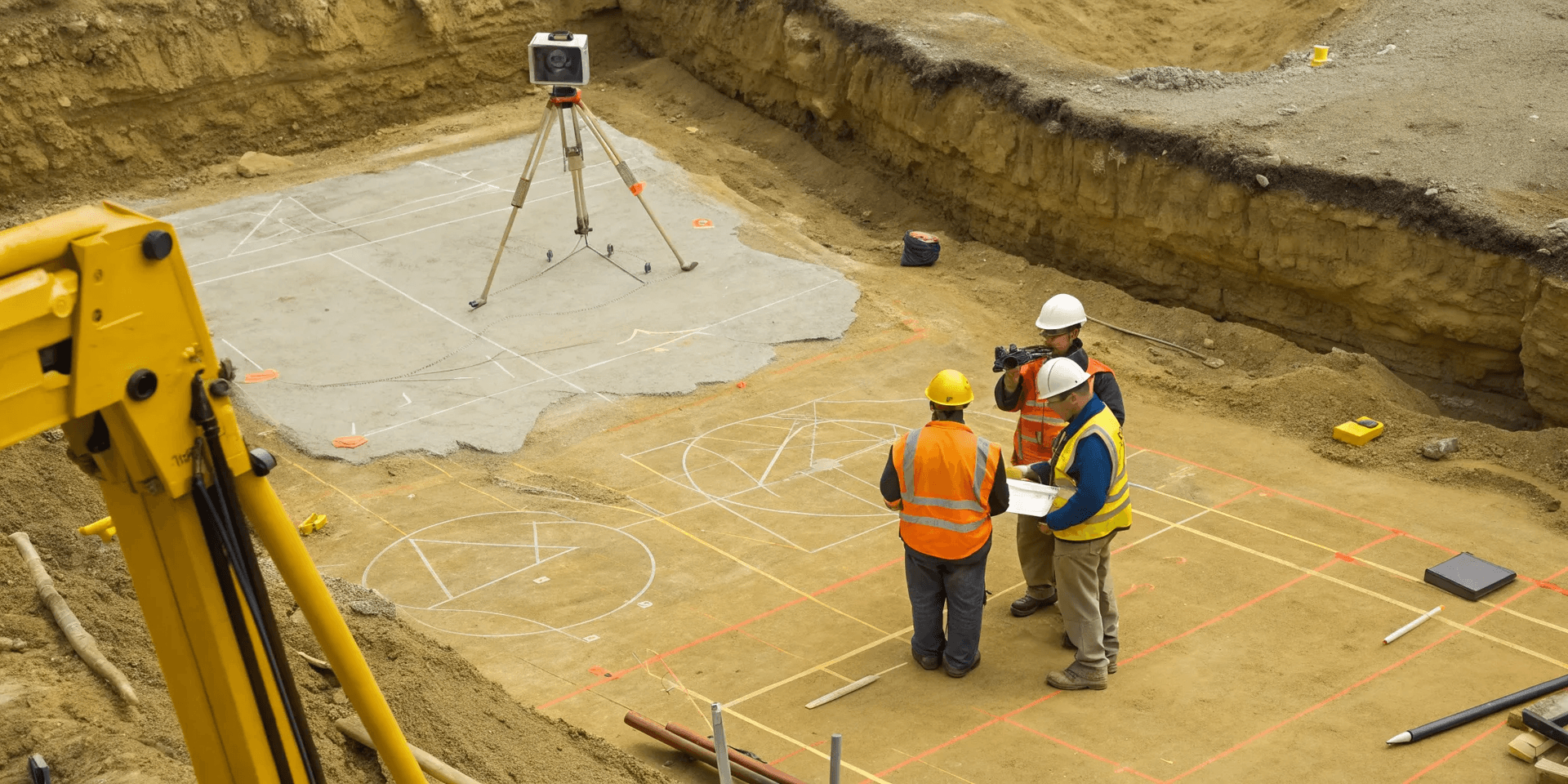
Collect and Analyze Field Data
With a clear strategy in place, our expert crews get to work. Using advanced GPR and EM equipment, they systematically scan the designated area to gather raw subsurface data. This isn’t a random search; it’s a methodical process of collecting information that will be analyzed to identify the location, depth, and type of buried infrastructure. Our technicians are trained to interpret complex signals in real-time, distinguishing between actual utilities and other subsurface anomalies. This hands-on analysis in the field is the first step in turning raw data into actionable intelligence for your project.
Ensure Data Accuracy
The quality of your locate depends entirely on two things: the skill of the technician and the quality of the technology. We invest in both. Our field crews are highly trained professionals who know how to operate their equipment to its fullest potential and troubleshoot challenging site conditions. Throughout the project, we perform quality checks to verify our findings and ensure the data remains consistent and accurate. This commitment to precision means you can trust the marks on the ground and the information in your report, reducing the risk of costly strikes and project delays.
Prepare Your Final Deliverables
The final step is transforming the field data into clear, usable formats for your team. We focus on creating deliverables that are immediately useful for your engineers, planners, and excavation crews. This includes precise field markings, detailed digital maps, and comprehensive reports summarizing our findings. Whether you need a CAD-ready file to drop into your designs or a detailed GPS & GIS map for long-term facility management, we prepare everything with clarity and usability in mind. You get a complete, easy-to-understand package that documents exactly what lies beneath your site.
What to Expect in Your Final Report
After the fieldwork is complete, the real value of a turnkey locating service comes to life in the final report. This isn't just a stack of papers; it's a comprehensive deliverable designed to give your team clear, actionable intelligence for your project. A professional report translates complex subsurface data into a format that engineers, project managers, and field crews can immediately put to use. It provides the documentation you need to move forward with confidence, ensuring everyone is on the same page and working from the same set of facts. This clarity is what prevents costly mistakes and keeps schedules from derailing.
The goal is to eliminate guesswork and provide a permanent record of what lies beneath your site. From CAD files for your design team to clear markings for your excavation crew, every component is created to support project safety, efficiency, and budget control. You’ll receive a complete package that not only guides your current work but also serves as a valuable asset for future site management and planning. It’s the critical link between the on-site investigation and successful project execution. Here’s a breakdown of what you should expect to find inside.
Digital Maps and CAD-Ready Files
Your final report will include precise, layered digital maps of the located utilities. These aren't simple sketches; they are detailed, georeferenced files ready to be dropped directly into your existing design software, like AutoCAD or GIS platforms. This seamless integration allows your engineering and planning teams to overlay the utility data onto project blueprints, making it easy to adjust designs, plan boring paths, or confirm clearance for new installations. Having accurate subsurface utility mapping in a CAD-ready format saves hours of manual data entry and reduces the risk of transcription errors, keeping your project moving forward without a hitch.
Detailed Technical Summaries
Alongside the maps, you’ll receive a technical summary that explains exactly what was done on-site. This report outlines the methodologies used—such as GPR or EM detection—and provides context for the findings. It will note any limitations encountered, such as areas with high signal interference or inaccessible depths, giving you a transparent look at the data. Think of it as the "how-we-did-it" section that builds confidence in the results. This summary is crucial for understanding the scope of the locate and making informed decisions, especially when dealing with complex sites or unknown infrastructure.
Clear Field Markings
A turnkey service connects the digital report to the physical job site. Before leaving your property, our crews will place clear, industry-standard markings on the ground using paint or flags. These markings correspond directly to the data in your digital maps, providing an immediate visual guide for your excavation team. This step is essential for on-site safety, as it gives equipment operators a real-time reference for the location of buried lines. It ensures that the detailed information from our utility locating services is communicated effectively to the people who need it most, right where the work is happening.
Complete Documentation Packages
Finally, everything is compiled into a single, organized documentation package. This includes the digital maps, technical summary, site photos, and any other relevant data collected during the project. Having all this information in one place provides a comprehensive record for compliance, stakeholder meetings, and future reference. It serves as your official record of due diligence, demonstrating that you took the necessary steps to identify and mitigate subsurface risks. This complete package ensures you have everything you need for your current project and any future work on the site.
Finding What Standard Locates Miss
Calling 811 is a critical first step for any excavation project, but it’s just that—a first step. The public utility locating service is designed to mark publicly owned lines, like the main gas, water, and electrical feeds running up to your property’s meter. But what about everything beyond that point? That’s where the real risk often lies. Standard locates don’t account for the complex network of private utilities, non-metallic pipes, deeply buried conduits, or undocumented infrastructure that crisscrosses nearly every commercial, industrial, and residential development.
Relying solely on a public locate leaves your project exposed to dangerous and costly surprises. A single unmarked private electrical line or forgotten sewer lateral can bring your job to a halt, cause expensive damages, or create a serious safety hazard. A turnkey locating partner goes beyond the public right-of-way to provide a complete picture of the subsurface. Using a combination of advanced technologies, we identify the critical infrastructure that standard services were never designed to find, giving your team the confidence to dig safely and keep the project moving forward.
Locating Private Utilities
Private utilities are any lines that are owned and maintained by the property owner, not the public utility company. Think about the power lines running from a main building to parking lot lights, the fiber optic cables connecting two campus buildings, or the irrigation lines watering the landscaping. Since these don't fall under the jurisdiction of public providers, the 811 service won't mark them. This creates a massive information gap for anyone digging on-site. Our private utility locating services focus specifically on identifying these assets, ensuring that your excavation plan accounts for every wire, pipe, and conduit on the property, not just the ones leading to the street.
Detecting Non-Metallic Lines
Many modern and older utilities are made from materials that are invisible to standard locating tools. Traditional electromagnetic (EM) locators work by detecting a current running through a metallic pipe or tracer wire. But what about PVC water lines, concrete storm drains, or fiber optic cables without a metallic sheath? These non-conductive lines can’t be found with EM equipment. This is where advanced tools like Ground Penetrating Radar (GPR) become essential. GPR sends radio waves into the ground and reads the reflections to create an image of what’s below, allowing us to detect non-metallic targets that would otherwise be missed.
Identifying Deep Targets
Utility depth can vary significantly across a site due to changes in grade, previous construction, or outdated installation practices. Standard locating equipment often has a limited depth range, meaning it can easily miss utilities buried several feet below the surface. This is especially common on large industrial sites or in areas where the landscape has been altered over time. A professional locating crew uses powerful GPR and EM equipment capable of reaching deeper targets. We also perform on-site inspections and cross-verify signals to confirm the depth and location of utilities, preventing dangerous surprises when you start trenching or drilling for soil borings.
Discovering Unknown Infrastructure
As-built drawings are often inaccurate, outdated, or simply non-existent. Properties that have been developed over decades frequently have abandoned pipes, old foundations, or forgotten septic tanks lurking just below the surface. These "unknowns" won't appear on any records and pose a significant risk to excavation crews. A comprehensive site scan is the only way to discover this hidden infrastructure. By performing a thorough subsurface utility mapping investigation, we create a new, accurate record of what’s actually in the ground, helping you avoid unexpected obstacles and the costly delays they cause.
Meeting Critical Project Standards
A successful project isn’t just about getting the job done—it’s about getting it done right. Turnkey utility locating is fundamental to meeting the strict standards that govern modern construction and environmental work. By providing a comprehensive and accurate picture of the subsurface, a professional locating partner helps you satisfy regulatory bodies, enforce safety plans, and keep your project moving forward without costly interruptions. It’s about building a foundation of certainty from the ground down, ensuring every phase of your project is built on reliable data.
Adhere to Regulatory Requirements
Every excavation project is subject to a complex web of local, state, and federal rules. Failing to meet these standards can lead to fines, work stoppages, and legal trouble. A turnkey locating service provides the detailed documentation you need to prove due diligence and maintain compliance. Just as telecom infrastructure must comply with specific deployment regulations, your project needs to show it has taken every step to identify and protect underground assets. Accurate subsurface maps and clear reports serve as your official record, demonstrating that you’ve met your obligations and are operating responsibly. This documentation is essential for smooth inspections and project approvals.
Follow Strict Safety Protocols
On any job site, safety is the top priority. A utility strike can cause serious injury, property damage, and long-term service disruptions. Professional locating is a critical component of any site safety plan, as it removes the guesswork that leads to accidents. Think about how building managers have specific rules and regulations for positioning heavy equipment to prevent structural damage; the same principle applies underground. Knowing the precise location of every utility allows you to plan excavation, drilling, and trenching with confidence. Clear, accurate field markings and detailed maps empower your crew to work safely and efficiently, protecting both your team and the surrounding infrastructure.
Manage Your Project Timeline
Unexpected discoveries underground are one of the most common causes of project delays. Hitting an unmarked utility line brings all work to a halt, idling expensive equipment and crews while you deal with the fallout. A turnkey locating service helps you get ahead of these problems. By identifying all potential conflicts before you break ground, you can create a realistic schedule and stick to it. This proactive approach is key to improving your project’s speed-to-market and keeping subsequent phases on track. When your team has a complete and accurate map of the subsurface, they can work without interruption, ensuring you meet your deadlines and stay on budget.
How to Choose the Right Locating Partner
Selecting a private utility locator is a critical decision that directly impacts your project's safety, timeline, and budget. The right partner does more than just mark lines; they provide the confidence you need to excavate without hitting costly or dangerous surprises. When you’re vetting potential companies, it’s important to look beyond the price tag and evaluate their expertise, technology, and overall approach to project support. A true partner integrates with your team, delivering clear, actionable data that keeps your job moving forward smoothly.
Verify Their Technical Expertise
Before you hire anyone, you need to be sure they truly understand the science behind locating. A skilled team doesn't just know how to operate the equipment—they know why one method works better than another in specific soil conditions or on a congested site. Don't be afraid to ask detailed questions. How do they approach a site with a mix of metallic and non-metallic lines? What is their process for identifying unknown utilities not shown on any records? A confident, knowledgeable partner will be able to explain their methods clearly and help you understand the limitations of the technology, ensuring there are no surprises down the road.
Ask About Their Equipment
The quality of a locate is directly tied to the quality of the equipment used. Outdated or poorly maintained gear can easily miss deeper targets or non-metallic lines like fiber optic cables and PVC pipes. Ask potential partners what technology they use. Do they have a range of Ground Penetrating Radar (GPR) antennas for different depths and conditions? Are their electromagnetic (EM) locators capable of multiple frequencies? A professional firm invests in modern, high-performance tools because they know it’s the only way to deliver accurate and reliable utility locating services. This investment is a clear indicator of their commitment to getting the job done right.
Check Their Response Time
When you’re ready to dig, you can’t afford to wait days for a locating crew to show up. Delays on-site have a ripple effect, pushing back schedules and increasing costs. Find out what a company’s typical mobilization time is. When you call, do you get a direct line to a project manager who understands your needs, or are you routed through a call center? A responsive partner respects your timeline and makes communication easy. They should be able to give you a clear schedule for fieldwork and deliverables, ensuring you have the data you need exactly when you need it.
Evaluate Their Project Support
A great locating partner provides comprehensive support from start to finish. This goes beyond just putting paint on the ground. They should deliver a complete package that makes your job easier, including clear field markings, detailed digital maps, and CAD-ready files that your engineers can use immediately. The goal of a turnkey service is to free you from having to manage the process. A partner who offers high-quality subsurface utility mapping provides a seamless experience, giving you the clear, documented results you need to move forward with confidence.
Frequently Asked Questions
I always call 811. Why do I need a turnkey service on top of that? Calling 811 is the right first step, but their service is designed to mark only public utilities leading up to your property’s meter. A turnkey service handles everything else. We identify all the private lines on your site, like power running to parking lot lights or water lines for an irrigation system. We also use advanced tools like Ground Penetrating Radar to find non-metallic pipes and other infrastructure that standard locates were never designed to detect.
What kind of project actually needs this level of detail? This service is valuable for any project that involves breaking ground, from trenching for a new fiber line to planning soil borings for a large foundation. If you need to dig with certainty and avoid hitting unknown infrastructure, a comprehensive locate is a smart investment. It's especially critical for complex sites, properties with a long history of development, or any job where a utility strike would cause significant delays and costs.
How quickly can you get a crew to my site and deliver the results? We know your project schedule is tight. Our process is built for speed, and we can typically get a crew to your site quickly after our initial consultation. The timeline for delivering final reports depends on the size and complexity of the area, but our goal is always to provide you with field-ready data without unnecessary delays. We skip the call centers so you can talk directly with our team to get a clear schedule.
What makes your maps and reports more useful than simple paint marks on the ground? While field markings are crucial for your on-site crew, they are temporary and can fade or wash away. Our final deliverables provide a permanent, actionable record for your entire project team. You receive precise digital maps and CAD-ready files that your engineers can drop directly into their designs. This ensures everyone is working from the same accurate information, which helps prevent planning errors and misinterpretations down the line.
Can you find utilities that aren't on any of my site plans? Yes, discovering undocumented infrastructure is one of the main reasons clients hire us. Many properties have abandoned lines, old foundations, or other buried objects that don't appear on any as-built drawings. By combining different detection methods, we create a new, accurate map of what’s actually in the ground, not just what the old records show. This helps you avoid costly surprises during excavation.