
GPR Concrete Scanning Cost: Your Complete Guide
Before you cut into a concrete slab, you’re facing two potential costs. The first is the predictable price of a professional GPR scan. The second is the massive, unpredictable expense of hitting a post-tension cable or a live electrical conduit. The gpr concrete scanning cost is an investment in certainty—a small price to pay to avoid catastrophic failures, costly repairs, and dangerous job site accidents. Understanding what drives this cost helps you see it not as an expense, but as one of the smartest insurance policies for your project’s safety, timeline, and budget.
Key Takeaways
- Treat GPR as an Investment, Not an Expense: The upfront cost of a professional scan is minimal compared to the massive, unpredictable expenses of a utility strike or structural damage. The price reflects your project's specific needs, but the real value comes from preventing costly mistakes.
- Prioritize Operator Skill Over Equipment: The most advanced GPR system is only as good as the technician interpreting its data. Vet providers based on their team's experience and quality control processes to ensure you get reliable, actionable results.
- Prepare Your Site for a Better Scan: You can improve the accuracy and efficiency of your GPR service with simple prep work. Providing a clear, dry work area and any existing site plans helps the technician deliver the best possible data for your project.
What is GPR Concrete Scanning?
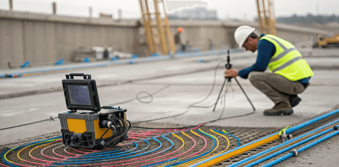
Think of GPR concrete scanning as a high-tech stud finder for concrete. It’s a non-destructive way to see what’s hidden inside a concrete slab, wall, or column before you cut, core, or drill. Using Ground Penetrating Radar (GPR), a technician can accurately locate rebar, post-tension cables, electrical conduits, and other embedded objects without causing any damage to the structure. This process is essential for maintaining structural integrity and ensuring job site safety.
Before you start a project that involves altering a concrete structure, you need to know exactly what you’re dealing with. Hitting a post-tension cable or a live electrical line can lead to catastrophic failures, costly repairs, and serious injuries. GPR scanning gives you a clear map of the subsurface, allowing your team to work with confidence and precision. It’s the modern, reliable alternative to outdated methods or simply guessing and hoping for the best. By getting a clear picture of the subsurface, you can plan your work effectively, avoid dangerous obstacles, and keep your project on schedule and within budget.
How GPR Technology Works
GPR operates by sending a tiny pulse of radio-wave energy into the concrete from an antenna. When this energy wave hits an object with different properties than the surrounding concrete—like a steel rebar or a PVC conduit—it bounces back to the surface. A receiver records the reflected waves, measuring how long it took for them to return. This data is displayed on a screen as a series of arches or hyperbolas. A trained technician interprets these signals to identify the type of object, its depth, and its location. It’s a completely non-destructive process, meaning we can gather critical data without drilling a single hole.
Common Applications and Key Benefits
GPR scanning is incredibly versatile and is used on job sites every day to prevent damage and delays. Common applications include clearing locations for core drilling, identifying safe areas for saw cutting, and locating structural beams before renovations. It’s also used to determine slab thickness, map out radiant heat tubes, and find voids beneath the concrete. The key benefits are clear: you enhance project safety by avoiding strikes on critical utilities or structural elements. This, in turn, leads to significant cost savings by preventing expensive repairs and project shutdowns. Ultimately, GPR gives you the accurate data you need to work more efficiently.
Understanding Accuracy and Limitations
It’s important to clear up a common misconception: GPR does not produce a crystal-clear, X-ray-like image of what’s inside the concrete. The raw data looks more like a series of black-and-white lines and curves on a screen. The real value comes from an experienced operator who can accurately interpret this data. While GPR is highly precise, its accuracy can be affected by certain conditions. For example, densely packed rebar or wire mesh can create complex reflections that are harder to decipher. High moisture content in the concrete can also limit the radar’s signal penetration. Despite these potential limitations, a skilled technician using professional-grade equipment can deliver reliable, actionable results for almost any project.
What Factors Drive GPR Scanning Costs?
When you’re planning a project, budgeting is everything. But GPR scanning isn’t a one-price-fits-all service. The final cost depends on what you need to find, where you’re looking, and how you need the data delivered. Think of it less like buying a product off the shelf and more like hiring a specialist for a custom task. The scope of that task determines the price.
Understanding the key variables will help you get a more accurate quote and ensure you’re paying for exactly what your project requires. From the size of your work area to the complexity of the underground environment, several factors come into play. A simple scan to clear a single boring location will naturally cost less than a comprehensive map of a congested utility corridor. Let’s break down the main elements that shape the cost of a professional GPR scan so you can plan your budget with confidence.
Project Size and Complexity
The most straightforward factor is the size of the area you need scanned. A larger footprint, like a full parking lot or a long trench path, simply takes more time for a technician to cover than a few small sections of a concrete slab. But size isn't the only thing that matters—complexity is just as important.
A small, congested area filled with overlapping pipes, rebar, and conduits can be far more time-consuming than a large, open field with a single utility line. When a site has multiple targets or challenging features, our technicians have to perform more detailed scans and spend extra time interpreting the data to give you a clear picture.
Site Location and Accessibility
Where your project is located plays a big role in the overall cost. Mobilization, which covers travel time and expenses for our crew and equipment, is a standard part of any quote. A project in a remote location will naturally have higher mobilization costs than one just down the road.
Accessibility on-site is another key consideration. An open, flat concrete slab is easy to work on. A cluttered mechanical room, an active construction zone with heavy equipment, or a sloped surface requires more time and careful maneuvering. These challenges can extend the time needed to complete the scan, which is reflected in the price.
Ground Conditions and Scan Depth
The type of material we’re scanning and how deep you need to see directly impacts the work involved. Different ground conditions, like clay, sand, or highly saturated soil, can affect how well GPR signals travel. Our experts know how to adjust their techniques for these conditions, but challenging soils can sometimes require more time for data interpretation.
Similarly, the required scan depth matters. Locating shallow conduits within a concrete slab is different from mapping a deep sewer line. Deeper targets often require specialized GPR antennas and more advanced analysis to filter out noise and accurately identify the utility, which can influence the final cost.
Data Analysis and Reporting Needs
What do you need to do with the information once the scan is complete? The answer drives a significant portion of the cost. If you just need utilities marked on the ground with paint or flags, the process is relatively quick. However, many projects require detailed documentation.
Creating a comprehensive report that explains our findings, including depth estimates and a site sketch, takes time back at the office. For more complex needs, we can deliver precise subsurface utility mapping with data integrated into CAD or GIS files. This level of detailed analysis and professional reporting requires specialized software and expertise, adding value and cost to the project.
Urgent or After-Hours Service
Sometimes, you can’t wait. We understand that project schedules are tight and unexpected issues pop up. If you need an emergency scan or require work to be done after normal business hours or on a weekend to avoid disrupting your operations, we can accommodate that.
This type of priority scheduling often comes at a premium rate. While it costs more upfront, arranging urgent utility locating services can save you from much more expensive delays or the catastrophic cost of a utility strike. It’s an investment in keeping your project on track and your team safe, no matter the timeline.
How Are GPR Services Priced?
When you’re budgeting for a project, you need clear numbers. While GPR pricing isn’t one-size-fits-all, most professional firms use a few standard models. The final cost depends on your project's scope, the complexity of the site, and the level of detail you need in the final report. Understanding these pricing structures helps you request an accurate quote and compare proposals effectively. It’s all about matching the right service level to your specific goals, whether you need a quick scan before drilling or a comprehensive map of a complex underground environment. Let's break down the most common ways GPR services are priced so you know exactly what to expect.
Basic vs. Advanced Scanning
The complexity of the job is the biggest factor in determining cost. A basic scan, where a technician locates and marks utilities or rebar in real-time on the surface, is on the lower end of the price spectrum. This is perfect for straightforward tasks like clearing a single boring location. Advanced scanning, however, involves more intensive data collection and post-processing back at the office. This could include creating a detailed 3D map of subsurface infrastructure. These subsurface utility mapping projects require more time and expertise, so they are priced higher, often falling between $1,000 and $5,000 per day.
Daily and Half-Day Rates
For most professional projects, GPR providers quote based on half-day or full-day rates. This structure ensures you have a dedicated crew and all the necessary equipment on-site for a set period, which is far more efficient than booking by the hour. While some freelancers might offer hourly rates around $200, established firms find that daily rates provide better value and more predictable scheduling for clients. A half-day rate is ideal for smaller, well-defined areas, while a full-day rate is standard for most construction sites, ensuring the crew has enough time to cover the area thoroughly and address any unexpected findings without rushing.
Flat-Rate Project Pricing
If your project has a clearly defined scope, many GPR firms will offer a flat-rate price. This is especially common for tasks like concrete scanning in a specific area, which can range from $1,000 to $2,000 per day. A flat rate gives you budget certainty, as the price is locked in regardless of minor on-site delays. This price typically includes the scan itself and a basic report or field sketch. If you need a more detailed, engineer-ready deliverable, that will likely adjust the cost. Always clarify what the flat rate includes before the project begins to ensure it covers all your utility locating service needs.
Discounts for Large-Scale Projects
Have a large or long-term project on the horizon? Don’t hesitate to discuss pricing. Most GPR companies are willing to offer discounted rates for extensive work. If you need scanning services for several weeks or across a large campus, a volume-based discount can provide significant savings. This approach benefits both you and the provider by establishing a predictable workflow and a strong working relationship. When requesting a quote for a large-scale project, be sure to provide as much detail as possible about the total area and timeline to get the most accurate and competitive rate.
Potential Additional Fees
To avoid surprises on your final invoice, it’s important to ask about potential additional costs upfront. A standard quote should cover the scan and a basic report, but other fees can apply. Common add-ons include travel and accommodation for projects far from the provider's office, costs for specialized data processing, or fees for creating detailed CAD files or formal reports. A transparent provider will outline all potential charges in their proposal. Always ask for a comprehensive quote that breaks down every line item so you can confidently manage your project budget from start to finish.
The Tech and Talent Behind a Quality Scan
When you're comparing quotes for GPR concrete scanning, it’s easy to focus on the bottom line. But the price tag doesn't tell the whole story. A truly reliable scan depends on a powerful combination of advanced technology, skilled operators, sophisticated software, and clear, actionable reporting. Think of it like hiring a photographer—you’re not just paying for the camera, but for the artist’s eye, their editing skills, and the final prints. Cutting corners on any one of these elements can lead to inaccurate data, which can cause dangerous and expensive project delays. A quality scan is an investment in certainty, and that value comes from getting every part of the process right. From the equipment used in the field to the final map you hold in your hands, each step builds on the last to give you a clear picture of what lies beneath the surface.
Types of GPR Equipment
Not all GPR carts are created equal. The equipment used for concrete scanning has to be tough enough to handle demanding job site conditions, but it also needs to be precise. Professional GPR providers use a range of antennas with different frequencies, because there’s no one-size-fits-all solution. High-frequency antennas are perfect for creating detailed, high-resolution images of shallow targets like rebar, conduits, and post-tension cables within a slab. For deeper targets, like utilities buried beneath the concrete, lower-frequency antennas are required. A seasoned provider will assess your project's specific needs and select the right tool for the job, ensuring you get the most accurate data possible from your utility locating services.
The Importance of Operator Expertise
The most advanced GPR system in the world is only as good as the person operating it. An experienced technician does more than just push a cart across the floor. They know how to interpret the raw data as it appears on the screen, identifying subtle patterns and anomalies that could signal a hidden utility or structural element. They can also combine GPR with other tools, like electromagnetic (EM) locators, to achieve what some firms report as 99.8%+ accuracy in identifying subsurface infrastructure. This on-the-ground expertise is critical for adapting to site conditions and ensuring a comprehensive scan. A skilled operator turns raw signals into reliable intelligence, giving you confidence in the results.
Professional Data Processing Software
Once the fieldwork is done, the raw GPR data—which looks like a series of black, white, and gray lines—needs to be translated into something you can actually use. This is where professional data processing software comes in. This software allows analysts to filter out background noise, layer the scan data onto your site plans, and create a clear, color-coded map of the subsurface. The goal is to produce an accurate as-built drawing that shows exactly where conduits, rebar, and other elements are located. This crucial step transforms complex GPR readings into a practical tool for your project team, forming the foundation of effective subsurface utility mapping.
What to Look for in a Final Report
The final report is the culmination of the entire GPR scanning process, and its quality is a direct reflection of the provider’s expertise. A great report is clear, concise, and immediately useful. It should include a detailed map or overlay on your existing drawings, with all findings clearly marked and color-coded. Depths should be provided for all located targets, so you know exactly how deep to cut or drill. An experienced company will deliver more accurate results because they know how to properly interpret the data. Your deliverable should be a field-ready document that your team can use to work safely and efficiently, without needing to decipher technical jargon or confusing imagery.
How to Choose the Right GPR Provider
Selecting the right GPR scanning partner is about more than just price—it’s about ensuring the safety of your crew and the integrity of your project. The quality of the data you receive depends entirely on the provider’s expertise, equipment, and processes. A cheap scan that misses a critical utility or structural element isn't a bargain; it's a liability waiting to happen. Before you hire a team, take the time to ask the right questions. A reputable provider will have clear, confident answers that give you peace of mind.
Verify Their Technical Qualifications
The GPR machine itself doesn't interpret the data; a skilled technician does. The raw output is a series of complex radargrams, and it takes years of hands-on experience to accurately identify rebar, conduit, and post-tension cables. Ask potential providers about the experience level of their field technicians—ideally, you want a team with at least five to ten years of dedicated GPR experience. Inquire about their training programs and how they ensure their operators can distinguish between different subsurface features. A company that invests in its people will deliver more reliable utility locating services and clearer results.
Ask About Their Equipment
Not all GPR equipment is created equal. The technology used for scanning concrete takes a beating on job sites, so it needs to be durable and well-maintained. A professional GPR provider will own a range of high-frequency and low-frequency antennas to adapt to different project needs, from mapping shallow rebar in a slab to identifying deeper utilities. Ask what kind of equipment they use and why it’s suited for your specific project. A one-size-fits-all approach is a red flag. The right tool ensures you get the necessary resolution and depth penetration for a complete and accurate picture of what’s below the surface.
Confirm Insurance and Certifications
This is a non-negotiable. Any contractor stepping onto your site should be fully licensed, bonded, and insured. This protects you and your project from liability in the event of an accident, property damage, or theft. Ask for a certificate of insurance and verify that their coverage is adequate for the scope of your project. A professional company will provide this documentation without hesitation. Skipping this step exposes your project to unnecessary financial and legal risks, so always confirm that your GPR provider has the proper credentials before they begin any work on your site.
Check Their Average Response Time
Construction and environmental projects rarely stick to a perfect 9-to-5 schedule. Delays happen, and sometimes you need a scan done urgently to keep things moving. Before committing to a provider, ask about their availability and average response time. Can they accommodate after-hours or weekend work if needed? A flexible partner who understands the time-sensitive nature of your work is invaluable. You want a team you can contact directly to get a crew on-site quickly, not one that makes you wait days for a callback or gets stuck in a call center loop.
Inquire About Quality Control
How does the provider ensure their findings are accurate? The best firms use a multi-faceted approach to quality control. For example, many top-tier providers combine GPR with electromagnetic (EM) locating to cross-verify findings and achieve accuracy rates above 99%. This dual-method approach helps locate both metallic and non-metallic targets, providing a much more complete picture. Ask about their process for data review and what steps they take to confirm their field markings. A commitment to rigorous subsurface utility mapping and quality assurance is the mark of a provider you can trust with your project’s safety.
Common Myths About GPR Scanning Costs
When you’re looking at a project budget, it’s easy to see GPR scanning as just another expense. But thinking of it as a simple line item can be a costly mistake. The price of a professional scan is often misunderstood, leading to decisions that prioritize short-term savings over long-term project health. Let's clear up a few common myths about what you’re really paying for when you invest in a quality GPR scan.
The truth is, the cost of GPR is directly tied to the value it provides: certainty. You're paying for advanced technology, deep expertise, and actionable data that protects your project from delays, damage, and unforeseen expenses. It’s less of a cost and more of an insurance policy against the expensive unknowns lurking beneath the surface.
The Upfront Cost vs. Long-Term Savings
One of the biggest hurdles is viewing the GPR scan as an optional expense rather than a critical investment. While there's an upfront cost, it’s tiny compared to the potential expenses of not scanning. Hitting a single utility line can lead to thousands in repair costs, project-halting downtime, and serious safety risks. As experts at Southeast Scanning note, GPR is a "game changer for avoiding costly mistakes." Think of it this way: the price of a scan is a fixed, predictable number. The cost of a utility strike, structural damage, or a major change order is unpredictable and almost always higher. Investing in professional utility locating services from the start is the most reliable way to protect your budget and timeline.
Why Not All GPR Equipment Is Equal
You might see a wide range of quotes for GPR services, and a lot of that difference comes down to the equipment being used. Not all GPR systems are created equal. Professional-grade equipment is built to be durable and rugged, capable of delivering clear, reliable data in tough field conditions. Cheaper, lower-frequency antennas might miss smaller targets or fail to penetrate to the required depth. At SiteTwin, we use multi-frequency GPR systems that provide the high-resolution data needed for a complete picture. This investment in technology means we can deliver the clean, engineer-ready results you need for accurate subsurface utility mapping and confident decision-making.
The Critical Role of Operator Skill
A GPR machine is a powerful tool, but it doesn't just spit out a map of the underground. It produces raw data that looks like a series of lines and arcs. The real magic happens when a highly trained technician interprets that data. As the team at Concrete Insight points out, "an experienced engineer needs to read the images." An unskilled operator can easily misinterpret feedback, miss critical targets, or create a report that’s more confusing than helpful. You're not just paying for the machine's time; you're paying for the years of experience our expert field crews bring to every job. That expertise is what turns raw data into reliable, actionable intelligence for your project.
The Complexity of Interpreting Raw Data
Even with the best equipment and a skilled operator, interpreting GPR data is complex. Site conditions play a huge role in scan quality. Things like dense rebar, wire mesh, soil moisture, and competing utility signals can create "noise" that obscures the targets you’re looking for. An experienced technician knows how to adjust settings on the fly and use advanced software to filter out this interference. They can distinguish between a conduit and a piece of rebar or identify overlapping utilities. This ability to handle complex, real-world conditions is what ensures the final report is accurate and trustworthy, giving you a clear path forward for your excavation or drilling work.
Get the Most from Your GPR Investment
Think of GPR scanning not as a project expense, but as an investment in certainty and safety. While there’s a line item for the service, its real value comes from preventing costly mistakes, keeping your crew safe, and ensuring your project stays on schedule. A quality scan gives you a clear picture of what’s inside the concrete so you can move forward with confidence. But how do you ensure you’re getting the absolute best return on that investment?
It comes down to a few smart, proactive steps. By planning ahead and understanding the process, you can help your GPR team deliver the most accurate data possible while keeping your budget in check. From preparing the site for a better scan to bundling services for cost savings, these simple strategies will help you maximize the benefits of GPR and protect your project from the ground up.
Plan Your Project for a Better Scan
A little prep work can make a huge difference in the quality of your GPR data. The technology works best on dry, fully cured concrete, where it can typically penetrate 18 to 24 inches. If the concrete is freshly poured or saturated with water, the GPR signal can be absorbed, making it harder to see deeper targets. Whenever possible, try to schedule your scan when conditions are dry. Also, providing your GPR technician with any existing as-builts or structural drawings can give them valuable context, helping them work more efficiently and interpret the data with greater accuracy.
Schedule Smart to Avoid Delays
It’s tempting to see a GPR scan as a potential delay, but it’s actually one of the best ways to prevent much bigger ones. A brief, planned pause for scanning is far better than an emergency shutdown caused by hitting a conduit or rebar. To keep your project flowing smoothly, schedule the GPR service well before any cutting, coring, or drilling is set to begin. This gives the technicians time to perform a thorough scan and provides you with the data you need to make informed decisions without holding up your crew. This proactive approach saves money and avoids hazardous conditions down the line.
Bundle Services to Save on Costs
If your project involves more than just concrete scanning, you can often save significantly by bundling services. Mobilization—getting a trained crew and specialized equipment to your site—is a key part of the cost. If you also need private utility locating in the surrounding area or a full subsurface utility map for future planning, scheduling it all with one provider at the same time is much more efficient. Instead of paying for multiple site visits, you cover one mobilization fee and get all your subsurface questions answered in a single, coordinated effort.
Calculate the Value of Reducing Risk
When you compare the cost of a GPR scan to the cost of a mistake, the value becomes incredibly clear. Accidentally cutting a single electrical conduit during a renovation can lead to repairs costing upwards of $12,000. If you hit a post-tension cable, that figure can jump to $30,000 or more for a single repair. A GPR scan is essentially an affordable insurance policy against these kinds of budget-breaking incidents. It’s a small, predictable cost that eliminates the risk of huge, unexpected expenses and keeps your project financially on track.
Meet Compliance Requirements with Confidence
Beyond the practical benefits, GPR scanning is a critical step for due diligence and safety compliance. Before you begin any concrete cutting, coring, or drilling, performing a scan is considered an industry best practice to prevent structural damage and protect workers. Many project specifications and insurance policies require it. Having a professional GPR report on file provides clear documentation that you took the necessary steps to identify and avoid subsurface hazards, protecting your team and your business from liability.
What to Expect in Your GPR Report
After the scan is complete, the real value comes from the final report. This isn't just a collection of raw data; it's a clear, actionable map of what lies beneath the surface. A professional GPR report translates complex readings into a straightforward guide that your team can use immediately in the field. It should give you the confidence to drill, cut, or trench without guesswork.
The goal is to provide you with clean, engineer-ready results that integrate seamlessly into your project plans. You should receive a detailed summary of all findings, including the location and depth of rebar, conduits, post-tension cables, and any other detected objects. The report should be easy to understand, whether you're an engineer reviewing CAD files or a foreman looking at a marked-up floor plan on-site. At SiteTwin, we focus on delivering data that prevents delays, not creates them.
Standards for Data Accuracy
When you’re about to cut into concrete, accuracy is everything. While no technology is perfect, professional GPR scanning delivers an extremely high degree of precision. By combining ground penetrating radar with other tools like electromagnetic (EM) locators, expert technicians can achieve accuracy rates exceeding 99%. This multi-tool approach helps verify findings and locate targets that GPR alone might miss, giving you a comprehensive picture of subsurface infrastructure.
This level of accuracy is the standard for reliable subsurface utility mapping. It means you can trust the markings on the ground and the data in your report to plan your core drills, saw cuts, and excavations safely. The final report should clearly state the confidence level of the findings, ensuring you understand exactly what was located and where.
Different Report Types and Formats
Your GPR report should be delivered in a format that works for your project. A one-size-fits-all approach doesn’t cut it when you have different teams needing different information. For field crews, a simple, clear PDF with photos and on-site markings might be perfect for quick reference. For engineers and architects, the data can be exported into detailed CAD or GIS files to create accurate as-builts or update existing plans.
This flexibility ensures the information is immediately useful. You can overlay the GPR data onto your structural drawings to visualize conflicts before they happen. The key is getting the information you need in a format you can easily work with and share, preventing miscommunication and keeping your project moving forward smoothly.
How Your Data Is Stored and Delivered
You need your GPR results fast, and they need to be clear. Modern GPR providers deliver reports digitally, typically via email or a secure download link, ensuring you get the information as soon as it’s processed. The deliverable should include a written report summarizing the scope of work and findings, along with visual aids like marked-up photos or site sketches.
For more complex projects, you might receive layered CAD files or detailed maps. The data is presented in a clean, organized way, free of confusing technical jargon. We focus on providing field-ready data that your crew can understand and act on without needing an expert to translate it. This direct and efficient delivery means you can move from scanning to action without unnecessary delays.
Our Commitment to Quality Assurance
A quality GPR report is the product of both advanced technology and human expertise. Our commitment to quality assurance starts with experienced field technicians who know how to interpret the complex data GPR produces. GPR has proven to be a highly effective method for non-destructive evaluation, but the raw scans require a trained eye to analyze correctly.
Every report we produce goes through a review process to verify the findings and ensure clarity. We stand by our results because we know they are used to make critical decisions on active job sites. Our process ensures that the final report you receive is not just accurate but also practical, giving you a reliable foundation for your work and protecting your project from the risks of the unknown.
Frequently Asked Questions
How long does a typical GPR scan take? The time needed for a scan really depends on the size and complexity of the area. A straightforward scan to clear a few core drilling locations on a concrete slab might only take a couple of hours. However, a larger or more congested area, like a mechanical room filled with overlapping conduits, could easily require a half-day or even a full day to map everything accurately and ensure no targets are missed.
Is GPR scanning safe for my site and my team? Absolutely. GPR technology is completely safe and non-destructive. It works by sending out a small pulse of radio waves, which is harmless to people and the surrounding environment. The process doesn't involve any radiation or drilling, so it can be performed safely in an active work area without disrupting other operations or posing any risk to your crew.
What's the main difference between GPR concrete scanning and the free 811 service? This is a great question because they serve two very different purposes. The 811 service is essential for locating public utility lines that run from the street to your property's meter. GPR concrete scanning takes over from there. It's used to find what’s inside a structure or on private property, like rebar, post-tension cables, and electrical conduits embedded within a concrete slab, or private utility lines that 811 doesn’t mark.
What do I need to do to prepare the area for a scan? A little preparation goes a long way in getting the best results. The most important step is to clear the scan area of any equipment, materials, or debris so the technician has direct access to the concrete surface. If possible, ensure the surface is dry, as excessive moisture can interfere with the radar signal. Having any existing site plans or structural drawings available can also help the technician work more efficiently.
Can GPR tell me exactly what type of pipe or conduit is in the concrete? GPR is excellent at determining the precise location, depth, and size of an object. While it can't definitively identify the material like an X-ray, a skilled technician can make a highly educated interpretation based on the signal's characteristics. For example, the way the radar reflects off a metallic pipe is different from how it reflects off a PVC conduit. This expert analysis is what turns the raw data into a reliable map for your project.