
The Ultimate Guide to Potholing Utilities
A single utility strike can bring your entire project to a grinding halt. The costs aren't just in repairs; they're in crew downtime, project delays, potential fines, and damage to your reputation. Most of these incidents are completely avoidable. They happen when teams rely on incomplete or outdated information. Instead of risking it, you can make a small upfront investment in certainty. By potholing utilities at critical points before major excavation begins, you create an accurate, verified map of the subsurface. This simple, proactive step is the best insurance policy against the catastrophic financial and safety risks of digging blind, protecting your bottom line and your team.
Key Takeaways
Verify Visually to Eliminate Risk: Potholing provides the final, undeniable proof of a utility's exact depth and location. This step moves your project from assumption to certainty, preventing the dangerous strikes and costly delays that derail timelines and budgets.
Pothole Smarter, Not Harder: Use potholing as a strategic verification tool, not a search mission. By starting with GPR and EM locating to map utilities first, you can dig fewer holes, save significant time and money, and minimize ground disturbance.
Get a Reliable Map for Future Work: The job isn't done until you have a clear, documented report. This final deliverable provides precise GPS coordinates, verified depths, and photos, creating a permanent record of your underground infrastructure that engineers and future crews can trust.
What is Utility Potholing (And Why It's a Must-Do)
Before you break ground, you need to know exactly what’s lying beneath the surface. While technologies like Ground Penetrating Radar (GPR) and Electromagnetic (EM) locating give us a powerful look underground, potholing provides the final, undeniable proof. Think of it as the last step in due diligence—the one that replaces assumptions with certainty. It’s a simple concept with a massive impact on project safety, budget, and timeline.
Utility potholing, also known as daylighting, is the process of excavating small, precise test holes to physically expose underground utilities. This allows your team to visually confirm the exact horizontal and vertical position of a pipe, cable, or conduit. Instead of relying on potentially outdated records or digital signals alone, you get eyes-on confirmation. This step is absolutely critical before any trenching, drilling, or excavation begins, as it eliminates the guesswork that leads to dangerous and expensive utility strikes. By confirming the depth and location of each line, you create a reliable map that protects your crew, your equipment, and your project's bottom line.
The "What" and "Why" of Potholing
So, what exactly is potholing? It’s a targeted excavation method where we make a series of small test holes to physically locate and identify underground lines. This isn't random digging; it's a strategic process guided by the data from our initial GPR and EM scans. The "why" is simple: it removes every last bit of uncertainty. Utility maps can be wrong, and even the best locating equipment has limitations in certain soil conditions. Potholing provides the ground truth, confirming the type, size, material, and precise depth of each utility. This information is essential for planning safe excavation routes and avoiding conflicts.
Preventing Dangerous and Costly Strikes
A single utility strike can bring your entire project to a halt. Hitting a fiber optic line can cause widespread outages, while striking a gas or electrical line can have catastrophic consequences for your crew and the public. Potholing is your best defense against these risks. By physically verifying the location of every critical utility, you can confidently plan your excavation. This proactive step is a core part of our private utility locating services, as it ensures the data we provide is not just accurate, but physically verified. It keeps your team safe, your project compliant, and your schedule intact.
Protecting Your Project's Bottom Line
The cost of a utility strike goes far beyond the initial repair bill. You have to account for crew downtime, project delays, potential fines, and the long-term damage to your company's reputation. When you compare these potential expenses to the cost of potholing, the choice is clear. Investing a little time and budget upfront to verify utility locations saves you from massive, unpredictable costs down the road. The accurate data gathered from potholing feeds directly into your subsurface utility mapping, giving your engineers and planners the reliable information they need to design efficiently and avoid costly conflicts from the start.
A Look at Potholing Methods and Technology
Potholing isn’t a one-size-fits-all process. The best approach depends on your site’s soil conditions, the type of utilities you’re looking for, and your project’s specific needs. Modern techniques are designed to be non-destructive, meaning they safely expose underground lines without damaging them. This precision is key to verifying the data gathered during the initial locating phase.
At SiteTwin, we use these methods to confirm the exact horizontal and vertical position of utilities marked by our GPR and EM equipment. By physically seeing the utility, we can provide you with 100% accurate depth measurements and location data. This final step removes all guesswork, giving your team the confidence to dig safely. Let’s walk through the most common methods and how they fit into a smart, technology-driven workflow.
Hydro Excavation
Think of hydro excavation as a highly controlled, powerful way to dig. This method uses high-pressure water to break up and liquefy the soil, creating a slurry. A large vacuum hose then immediately removes that slurry and transfers it to a debris tank. Because it’s so precise, it’s one of the safest ways to expose sensitive utilities like fiber optic cables or gas lines without causing damage. This technique is incredibly efficient and creates a clean, well-defined hole, making it easy to take exact measurements. By preventing accidental strikes, hydro excavation not only protects assets but also keeps your project on schedule and your team safe. It’s a go-to choice for congested underground environments where precision is non-negotiable.
Air and Vacuum Excavation
Similar to hydro excavation, air and vacuum excavation uses a two-part process to clear soil away from underground utilities. But instead of water, it uses highly compressed air to fracture the ground. A powerful vacuum then sucks up the loosened dirt and rock. This method is even gentler than its hydro counterpart, as the operator can adjust the air pressure for different soil types. Because it doesn't introduce water into the ground, the excavated soil remains dry and can often be used to backfill the hole immediately. This makes air vacuum excavation an excellent option in areas where soil stability is a concern or where introducing water could cause issues, such as around certain electrical conduits or in landscaping you want to preserve.
Pairing Potholing with GPR and EM Locating
Potholing on its own is just digging a hole. Its real power comes from being the final verification step in a comprehensive subsurface investigation. Before we ever break ground, we use technologies like Ground Penetrating Radar (GPR) and Electromagnetism (EM) to create a detailed map of what’s below. These tools show us where utilities are located, but potholing confirms it with visual evidence. By combining potholing with technologies like GPR, we get the best of both worlds: the broad, detailed view from the scan and the undeniable proof from the exposure. This integrated approach eliminates uncertainty, confirms the material and depth of a line, and ensures the data you receive is completely reliable before you start trenching or drilling.
Integrating Data with Digital Maps
The goal of any project should be to pothole smarter, not harder. Starting with a clear and reliable picture of the subsurface is the best way to do that. When you have accurate utility mapping from the very beginning, potholing shifts from a search mission to a quick verification process. Instead of digging multiple holes to find a utility, crews can dig a single hole to confirm its exact depth. This is where our subsurface mapping services make a huge difference. We deliver clean, engineer-ready digital maps that show your team where utilities are before they arrive on site. This allows for more strategic potholing, saving you significant time and money while minimizing ground disturbance. It’s about turning raw data into actionable intelligence.
Staying Safe and Compliant on Site
A successful potholing operation isn’t just about accuracy—it’s about running a clean, safe, and compliant site from start to finish. When you’re exposing live utilities, there’s no room for error. A professional crew understands that safety protocols and regulatory adherence are just as critical as the excavation itself. This commitment protects everyone on site, minimizes liability, and keeps your project on track without unnecessary and costly interruptions.
At SiteTwin, we build our workflow around a safety-first mindset. From the moment our crew arrives, every action is guided by established best practices designed to protect your property, our team, and the critical infrastructure underground. This isn't just about checking boxes; it's about creating a controlled environment where precise, technical work can be done right the first time. By integrating safety and compliance into every step, we ensure the data we deliver is not only accurate but also obtained responsibly.
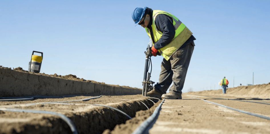
Essential Safety Gear
You can spot a professional crew by what they wear. Proper personal protective equipment (PPE) is the first line of defense against job site hazards. For potholing, this is non-negotiable. Our teams are always equipped with essentials like hard hats, high-visibility vests, steel-toed boots, and protective eyewear. Because hydro excavation involves pressurized water, waterproof gloves and gear are also standard. This equipment ensures our technicians can focus on the task at hand without risking injury, maintaining a secure and efficient work environment for everyone involved in the project.
Following Local and Federal Guidelines
Working around underground utilities is governed by a strict set of rules, and for good reason. Adhering to local and federal guidelines is crucial for site safety and avoiding hefty fines. This includes following all OSHA excavation standards and securing any necessary permits before digging begins. A qualified potholing provider will be well-versed in these requirements and manage the compliance process for you. This ensures every excavation is performed legally and safely, giving you peace of mind and protecting your project from regulatory setbacks that could cause significant delays.
Minimizing Your Environmental Impact
Modern excavation is about more than just moving dirt; it’s about doing so responsibly. Potholing is an inherently low-impact method because it creates minimal ground disturbance compared to traditional trenching. By using hydro or air excavation, we create small, precise holes that expose utilities without widespread digging. This approach preserves the surrounding landscape, reduces soil erosion, and minimizes the risk of contamination. It’s a smarter, more surgical technique that respects your property and aligns with today’s standards for environmentally conscious construction and site investigation.
Our Quality Control Checklist
Accuracy is everything. An incorrectly marked utility is just as dangerous as an unknown one. That’s why our process includes a rigorous quality control checklist. Before we even begin potholing, we use GPR and EM locating to pinpoint targets. After excavation, we visually confirm the utility’s type, size, material, and precise depth. We document everything with field notes and photos, ensuring the data you receive is verified and actionable. Attempting this without the right skills can lead to major project complications, which is why our expert crews handle every step with precision.
How to Plan a Potholing Project
A successful potholing project doesn’t start when the truck arrives on site—it begins with a solid plan. Thinking through the details beforehand is the best way to ensure the work is done safely, efficiently, and on budget. It helps you avoid surprises, prevent utility strikes, and get the precise data you need to move forward with confidence. A little preparation up front saves you from major headaches down the road, keeping your project on schedule and your team safe. Let’s walk through the key steps to get your site ready for potholing.
Start with a Thorough Site Assessment
Before any digging begins, a full site assessment is essential. This first step involves gathering and reviewing all available utility maps, as-builts, and public records from 811. But records alone don’t tell the whole story. That’s why we pair this research with a comprehensive subsurface utility mapping survey using GPR and EM locators. This process helps us identify the best locations for potholing and choose the right equipment for the job. Careful planning at this stage is your best defense against unexpected damage and costly project delays.
The Utility Marking and Locating Process
Once we have a clear picture from the initial assessment, the next step is to mark the ground. This is where we physically verify the horizontal location of buried utilities. Potholing is crucial because even the best records can be inaccurate. Underground lines can shift over time, and old maps might not reflect the true conditions. By exposing a small section of each utility, we confirm its exact position and depth, providing the certainty needed for any excavation, from installing new fiber lines to planning soil borings. This verification step ensures you’re digging in the right place, every time.
Accounting for Weather and Soil Conditions
Your site’s conditions play a big role in how we approach the project. Loose, sandy soil might require different safety precautions than dense clay to prevent cave-ins. Weather is another key factor. Fortunately, modern excavation methods are incredibly versatile. For example, hydro excavation can be performed year-round, even on frozen ground, by using heated water to break through the frost. This flexibility means your project doesn’t have to stop for winter. We always assess the soil and weather to select the safest and most effective method for your specific site.
What Documentation Do You Need?
The job isn’t finished until the data is in your hands. After we’ve exposed and surveyed the utilities, we create a detailed report that serves as a permanent record of what’s underground. This documentation includes the precise GPS coordinates, depth, size, and material of each utility, supported by clear photographs. This isn’t just a piece of paper; it’s an actionable tool you can hand to your engineers and excavation crews. Having this clean, field-ready data ensures everyone working on the site has the accurate information they need to proceed safely and avoid future conflicts.
What Does Potholing Cost?
One of the first questions we get about any project is, "What's the budget?" When it comes to potholing, the answer isn't a simple flat rate. The final cost depends on a mix of factors, from the equipment needed to the conditions at your specific site. Think of it less like buying a product off the shelf and more like commissioning a custom service tailored to your project's unique needs. Understanding these variables will help you plan your budget and see why a one-size-fits-all price just doesn't work. Let's break down the key components that influence the cost of potholing.
Equipment and Labor Costs
The biggest line items on a potholing invoice are typically the equipment and the skilled crew operating it. The primary tool is usually a hydro or air excavation truck, which is a significant piece of machinery. The cost is directly tied to how long our team and equipment are on your site. The duration of the job is influenced by the number of holes you need, their required size and depth, and logistical factors like how close the site is to a water source for the hydro-vac truck and an approved location for soil disposal. A straightforward project with a few shallow holes will naturally cost less than a complex one requiring extensive digging.
How Project Scope Affects the Price
The scale of your project is a major cost driver. While averages can range from $2,000 to $5,000 per hole, this figure is just a starting point. The total expense is determined by the number of test holes required to verify the utilities in your project area. A small-scale renovation might only need a couple of holes, while a large commercial development could require dozens. The complexity of the job also plays a role. Deeper utilities take longer to expose, and working in congested areas with multiple overlapping lines requires more precision and time, which can increase the overall cost.
The Impact of Site Conditions on Your Budget
Every site has its own personality, and its conditions can significantly influence your budget. The type of soil we’re digging in is a perfect example. Soft, loamy soil is much easier and faster to excavate than dense clay, rocky ground, or frozen earth. Difficult soil conditions may require more time or specialized techniques, which adds to the cost. Site accessibility is another key factor. Can we easily drive a large vacuum truck right up to the dig location? Or is the area remote, fenced off, or located in a tight urban space? Navigating these challenges requires extra planning and time, which is reflected in the final price.
Factoring in Other Services
While it might seem counterintuitive, spending a little on other services upfront can actually save you a lot on potholing costs. This is where a proactive approach pays off. By using non-destructive methods like subsurface utility mapping first, we can pinpoint the horizontal location of utilities with incredible accuracy. This preliminary step helps us identify the most critical spots to dig, drastically reducing the number of holes needed to verify depth and type. Fewer holes mean less time on site, lower labor and equipment costs, and minimal disruption to your project schedule. It’s the smartest way to get the certainty you need without unnecessary digging.
Potholing Best Practices for Accurate Results
Potholing is more than just digging; it’s a precision process that confirms what’s happening beneath the surface. When done right, it eliminates guesswork and gives your team the confidence to move forward safely and efficiently. Following a clear set of best practices ensures every test hole delivers maximum value, protecting your crew, your timeline, and your budget from unexpected surprises. It’s about turning subsurface unknowns into concrete, actionable data you can build on.
Plan Before You Dig
A successful potholing project starts long before the excavator arrives. The first step is always a thorough review of existing utility maps and records. This initial research, combined with professional utility locating services, creates a preliminary map of what to expect. From there, we can determine the optimal locations for test holes and select the right equipment for the job, whether it's hydro, air, or vacuum excavation. This careful planning phase is critical for minimizing site disruption and preventing accidental damage, ensuring the entire process runs smoothly from start to finish.
Prioritizing Damage Prevention
The primary goal of potholing is to prevent dangerous and costly utility strikes. Hitting a gas line, fiber optic cable, or water main can bring a project to a screeching halt, leading to expensive repairs, fines, and significant delays. By physically exposing utilities at critical points, potholing verifies their exact location and depth, removing any doubt left by remote locating methods. This proactive step is the ultimate form of damage prevention. It protects your assets and your team, keeping your project on schedule and your budget intact by confirming a clear path for excavation, trenching, or boring.
How We Verify Utility Location and Depth
There’s no substitute for visual confirmation. While GPR and EM locating are excellent for identifying the presence of underground lines, potholing is how we verify the details with 100% certainty. Once a utility is carefully exposed, our crews document its precise horizontal position and vertical depth. We also identify the utility type, size, and material. This high level of accuracy is essential for any design or construction work. The data gathered allows engineers to finalize plans with confidence, knowing they are working with real-world, field-verified information rather than estimates from old records.
Delivering Clean, Actionable Data
The job isn’t finished once the hole is backfilled. The real value of potholing comes from the clear, usable data it produces. After verifying each utility, we compile a comprehensive report that includes detailed measurements, site photos, and precise GPS coordinates. This information is then integrated into your site plans or a subsurface utility map, creating a permanent and reliable record of your underground infrastructure. This clean, engineer-ready data streamlines planning for future projects, simplifies maintenance, and provides a critical safety reference for anyone working on your site.
Frequently Asked Questions
Why do I need potholing if I’ve already called 811? Calling 811 is an essential first step, but it only covers public utilities running to your property line or meter. It won’t show you any of the private lines on your site, like power to an outbuilding, irrigation systems, or old, abandoned pipes. Potholing is the final step that physically confirms the exact depth and location of both public and private utilities, removing the guesswork that leads to dangerous strikes.
Is potholing really worth the cost? Think of it as project insurance. The cost of a single utility strike—factoring in repair bills, crew downtime, project delays, and potential fines—can easily dwarf the upfront investment in potholing. By verifying the location of critical lines before you dig, you are trading a small, predictable expense for protection against a massive, unpredictable financial and safety risk.
Do I still need GPR or EM locating if I'm going to pothole anyway? Yes, absolutely. GPR and EM locating create the map, while potholing confirms the key landmarks. The initial scans give us a broad picture of everything underground, allowing us to be strategic about where we dig. Without that data, potholing becomes a guessing game. Using them together ensures we dig fewer holes with greater accuracy, saving you time and money.
Which potholing method is better: hydro or air excavation? The best method really depends on your specific site conditions. Hydro excavation uses high-pressure water and is extremely effective in tough or frozen soil. Air excavation is a gentler option that uses compressed air, which is perfect for sensitive areas or when the excavated soil needs to be used for immediate backfill. We’ll assess your project to determine the safest and most efficient approach.
How disruptive is the potholing process to my site? It’s designed to be a low-impact process. Unlike trenching, which disturbs a large area, potholing involves digging small, precise test holes only where needed. The excavation methods are surgical, and once we’ve gathered the data, the holes are backfilled, leaving your site clean with minimal evidence that we were ever there.