
Subsurface Utility Engineering: A Practical Guide for Construction
Calling 811 is a critical first step for any excavation, but it’s far from the whole story. The public one-call service only marks public utilities, leaving you completely in the dark about private lines, abandoned pipes, and non-metallic conduits running through your site. Hitting one of these unknown lines can bring your project to a screeching halt, leading to costly repairs, dangerous conditions, and frustrating delays. This is where subsurface utility engineering (SUE) comes in. It’s a comprehensive process that goes beyond public markings to create a reliable, field-ready map of everything buried underground, giving your team the confidence to dig safely and efficiently.
Key Takeaways
Go Beyond 811 for True Risk Management: SUE provides a complete map of all underground utilities, including private and non-metallic lines, allowing you to proactively design around conflicts and prevent costly strikes, change orders, and project delays.
Match Data Quality to Project Risk: The four SUE Quality Levels (D through A) offer a clear standard for data accuracy. This allows you to strategically invest in the highest level of certainty only where it's needed most, like in high-conflict areas, saving time and money.
Integrate SUE into Your Design Phase: Bringing a SUE provider in at the start of your project is the most effective way to use the data. It allows your engineers to design around existing infrastructure from the beginning, eliminating the need for expensive and time-consuming redesigns later on.
What is Subsurface Utility Engineering (SUE)?
Think of Subsurface Utility Engineering (SUE) as the practice of creating a reliable map of everything buried beneath your job site. It’s a systematic process that goes far beyond just calling 811. While the public one-call service is a necessary first step, it often leaves significant gaps, missing private lines, abandoned pipes, or non-metallic utilities. SUE is the engineering discipline that fills in those blanks. It combines geophysics, surveying, and civil engineering principles to give you a complete and accurate picture of the underground environment.
According to the Federal Highway Administration, SUE is an engineering practice that manages the risks associated with underground utilities. Instead of reacting to problems as they happen—like a costly utility strike—SUE allows you to plan proactively. By using advanced tools and a standardized process, SUE professionals can locate, identify, and map subsurface infrastructure during the design phase. This means fewer surprises, safer excavations, and a smoother project from start to finish. It’s about replacing guesswork with data, ensuring your project team can make informed decisions before the first shovel ever hits the ground.
What Does SUE Actually Do?
At its core, SUE is all about investigation and documentation. The main goal is to find, identify, and map the horizontal and vertical positions of all underground utilities within your project limits. This includes everything from active water mains and fiber optic cables to old, forgotten pipes that don't appear on any records. The Common Ground Alliance highlights SUE as a critical process for the planning stage of any construction project. By creating a detailed subsurface map early on, you can design around potential conflicts, avoiding the need for expensive and time-consuming relocations later. It’s the difference between knowing what’s down there and just hoping for the best.
How SUE is Used in Construction
In construction, SUE provides the critical data needed for effective project planning and execution. The information gathered through SUE helps engineers and contractors design with confidence, knowing they have an accurate layout of the existing underground infrastructure. This allows them to strategically place new foundations, plan trenching routes, and schedule work without worrying about hitting a critical utility line. By integrating subsurface utility mapping into the pre-construction phase, you can significantly reduce the risk of utility strikes, which not only cause dangerous conditions but also lead to budget overruns and project delays. It’s a foundational step that sets the entire project up for success.
SUE's Role in Environmental Projects
For environmental consultants, SUE is an indispensable tool for site assessments and remediation. Before you can plan soil borings or install monitoring wells, you need to know exactly what’s underground. Hitting a sewer line or an electrical conduit during an environmental investigation can lead to cross-contamination, hazardous spills, or serious safety incidents. SUE provides the detailed utility map needed to select safe and effective sampling locations. This ensures the integrity of your environmental data and protects your team and the site from accidental damage. It’s a crucial step for any project that involves breaking ground, ensuring you can work efficiently without creating new environmental liabilities.
What Are the SUE Quality Levels?
When you’re planning an excavation or design project, you can’t afford to guess what’s underground. Subsurface Utility Engineering (SUE) provides a standardized framework to classify the accuracy of utility data, so you know exactly what level of risk you’re dealing with. Think of it as a grading system for underground information, ranging from a rough sketch to a precise, verified map.
These standards, developed by the American Society of Civil Engineers (ASCE), are broken down into four distinct "Quality Levels." Starting with Quality Level D (the least certain) and progressing to Quality Level A (the most certain), each level builds upon the last, giving you a clearer picture of the subsurface environment. Understanding these levels is key to making smart decisions, managing your budget effectively, and preventing costly surprises. It allows you to match the quality of the data to the needs of your project, ensuring you invest in the right information at the right time. This systematic approach moves your project from relying on old, questionable records to working with verified, field-collected data.
Quality Level D: Starting with Existing Records
Quality Level D is the starting point for any SUE investigation. This level involves gathering and reviewing existing utility records, such as as-built drawings, distribution maps, and other historical documents. According to the Federal Highway Administration, this information is primarily used for initial project planning and route selection. It gives you a general idea of which utilities might be present in your project area.
However, it’s important to treat this data as a clue, not a fact. These records are often outdated, inaccurate, or incomplete. A line may have been moved years ago without any documentation, or a new one installed. QL-D is a necessary first step, but it’s the least reliable level of information and should never be used for design or excavation purposes.
Quality Level C: Surveying What's Visible
Quality Level C takes the information from QL-D and adds a layer of real-world observation. At this stage, a survey crew visits the site to identify and map all visible, above-ground utility features. This includes manholes, valve boxes, utility poles, fire hydrants, and pedestals. The locations of these features are then surveyed and correlated with the existing records gathered in the previous step.
This process helps reconcile the paper records with what’s actually on the ground. As noted in the industry standard, this step often reveals significant discrepancies between records and reality. While QL-C provides a more reliable picture than records alone, it still doesn’t tell you the precise horizontal or vertical location of the utilities between the visible points. It’s a step up in confidence, but there are still major gaps in the data.
Quality Level B: Detecting with Technology
Quality Level B is where we bring in advanced technology to actively search for buried utilities. This is a huge leap in accuracy and is often referred to as "designating." Using geophysical instruments like Ground Penetrating Radar (GPR) and electromagnetic (EM) locators, technicians can determine the horizontal position of conductive and non-conductive lines. This is the core of professional private utility locating services.
This process is essential for identifying utilities that were never documented or were marked incorrectly on old plans. The data collected allows us to create a comprehensive 2D map of the subsurface infrastructure. QL-B provides a reliable layout of what’s underground, making it suitable for design and for planning excavation activities with a much lower risk of utility strikes. It tells you what is there and where it is horizontally.
Quality Level A: Exposing and Confirming
Quality Level A is the highest and most accurate level of utility data you can obtain. Often called "locating" or "potholing," this step involves physically exposing a utility to verify its exact location. This is typically done using non-destructive methods like vacuum excavation to safely dig a small test hole directly over the designated utility.
By exposing the line, we can collect precise horizontal and vertical measurements. According to SUE standards, QL-A also provides critical information on the utility’s size, material, condition, and depth. This level of certainty is crucial in high-risk areas, especially when designing new infrastructure that needs to connect to or cross existing lines. It removes all ambiguity and provides the ground-truth data needed for final design and construction, ensuring your project proceeds safely and without conflict.
Key SUE Methods and Technologies
Ground Penetrating Radar (GPR)
Think of Ground Penetrating Radar (GPR) as a high-tech fish finder for the ground. It works by sending a tiny pulse of energy into the soil and recording the echoes that bounce back from buried objects. The real advantage of GPR is its ability to detect both metallic and non-metallic utilities. This means we can find things like PVC water lines, concrete storm drains, and fiber optic conduits that other technologies might miss. By analyzing the GPR data, our technicians can identify the location and depth of these hidden lines, providing a more complete subsurface utility map for your project.
Electromagnetic (EM) Locating
While GPR is great for finding a wide range of materials, electromagnetic (EM) locating is the go-to method for metallic pipes and cables. This technique uses a transmitter to send a specific radio frequency through a conductive utility line. A handheld receiver then picks up this signal from the surface, allowing our crew to trace the line's path with incredible precision. It’s a highly effective way to map electrical cables, copper communication lines, and steel or cast-iron pipes. We often use EM locating and GPR together to confirm findings and ensure we’ve identified every type of utility on your site.
Vacuum Excavation
When you need absolute certainty about a utility's location—down to the inch—vacuum excavation is the answer. This is how we achieve Quality Level A data. Instead of using a backhoe or shovel, which could easily damage a critical line, we use a non-destructive digging method. A high-pressure stream of air or water safely loosens the soil around the utility, and a powerful vacuum removes the debris. This carefully exposes the pipe or cable, allowing us to record its exact horizontal position and vertical depth. It’s the safest and most accurate way to visually confirm what’s underground before you start trenching or drilling.
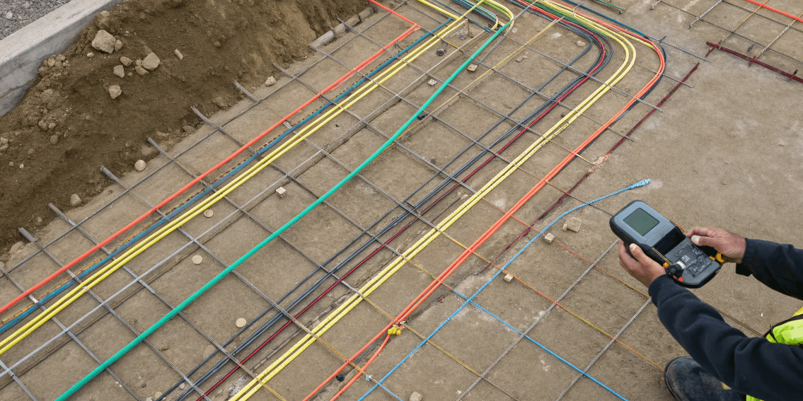
Digital Mapping and GIS
Finding utilities is only half the battle; you need that information in a format your team can actually use. After collecting data in the field, we process it and create detailed digital maps. This information is typically delivered in formats like CAD or integrated into a Geographic Information System (GIS). The result is a clean, easy-to-read map that overlays all the located utilities onto your site plan. This deliverable becomes a critical tool for your engineers, architects, and field crews, allowing them to plan their work with a clear understanding of the subsurface environment and avoid costly conflicts during construction.
How We Ensure Accurate Data
Accuracy isn't accidental—it's the result of a systematic process. We ensure reliable data by applying the appropriate SUE Quality Levels to your project. These levels, defined by the American Society of Civil Engineers (ASCE), act as a guide for how much effort and which technologies are needed to reach a specific level of confidence. By discussing your project's risk tolerance and design needs upfront, we can tailor our investigation. This ensures you get the precise data required for safe and efficient planning without paying for unnecessary work. It’s about matching the right methods to the right problem to deliver field-ready results you can trust.
How SUE Protects Your Project and the Environment
Subsurface Utility Engineering is much more than just finding pipes and cables before you dig. Think of it as a comprehensive risk management strategy for your entire project. When you know exactly what’s happening beneath the surface, you can protect your budget, your timeline, your crew, and the surrounding environment. Ignoring the underground is one of the biggest gambles in construction, but SUE gives you the data to make informed decisions instead of costly assumptions. It’s the difference between moving forward with confidence and hoping for the best.
By integrating SUE into your workflow, you’re not just adding a preliminary step; you’re building a foundation of certainty that pays off from the first survey to the final sign-off. This process systematically reduces the unknowns that can sink a project, turning potential liabilities into manageable data points on a map. From preventing dangerous accidents to avoiding environmental spills and costly redesigns, SUE provides a clear, actionable picture of the subsurface. It empowers your team to work smarter, safer, and more efficiently. Let’s look at the specific ways this process safeguards your work.
Reducing Project Risks
Every project manager knows that unforeseen issues can derail a schedule and inflate a budget. A utility strike is one of the most disruptive and expensive problems you can face. It brings work to a halt, requires emergency repairs, and often leads to hefty fines and project delays. SUE directly addresses this by providing a clear map of underground infrastructure before design and excavation begin.
This allows your engineers to design around existing utilities, preventing conflicts that would otherwise require costly change orders down the line. With accurate subsurface utility mapping, you can plan your excavation with precision, avoid clashes, and keep your project moving forward smoothly. It’s a proactive investment that prevents reactive, budget-breaking emergencies.
Meeting Regulatory Standards
Following industry best practices isn't just about efficiency; it's also about compliance. Subsurface Utility Engineering is a recognized standard for managing the risks associated with underground utilities. In fact, the Federal Highway Administration (FHWA) has encouraged the use of SUE on federal-aid projects for decades, recognizing its value in preventing conflicts and improving safety.
For projects involving public right-of-ways or federal funding, incorporating SUE is often a key part of meeting regulatory expectations. Adhering to these standards demonstrates due diligence and a commitment to responsible project management. It shows you’ve taken the necessary steps to identify and mitigate risks, which can be crucial for securing permits and satisfying stakeholders.
Keeping Your Crew Safe
Nothing is more important than the safety of your team. Excavating without knowing what lies beneath the surface puts every crew member at risk. Accidentally striking a high-voltage electrical line or a pressurized gas main can have catastrophic consequences. SUE removes the dangerous guesswork from excavation by providing a reliable map of buried hazards.
When your team has accurate data from utility locating services, they can dig with confidence, knowing where to proceed with caution and which areas to avoid entirely. This clear visualization of the subsurface is one of the most effective tools you have for preventing accidents, protecting your workers, and maintaining a safe job site for everyone involved.
Protecting the Site Environment
A utility strike doesn't just impact your project; it can also cause significant harm to the surrounding environment. Hitting a sewer line can contaminate soil and groundwater, while a damaged water main can cause erosion and flooding. These incidents often require extensive and expensive environmental cleanup efforts, not to mention the potential for regulatory penalties.
SUE is a critical practice for environmental stewardship. By accurately identifying and mapping all subsurface utilities, you can prevent accidental ruptures and spills that threaten local ecosystems. This is especially vital for projects near sensitive areas like wetlands or waterways. Proactive utility mapping ensures your project proceeds not only safely and efficiently but also with respect for the environment.
Putting SUE to Work: Best Practices
Simply hiring a SUE provider isn’t enough to guarantee a smooth project. How you integrate the process into your workflow makes all the difference. Getting the most out of SUE means treating it as a foundational step, not a last-minute checkbox. When you approach it strategically, you move from simply finding utilities to proactively managing subsurface risk. This shift saves you from dealing with costly surprises, change orders, and dangerous situations down the line.
Think of these practices as your playbook for turning subsurface data into a real project asset. By building SUE into your project from the start and ensuring clear communication, you set the stage for a safer, more efficient, and predictable build. It’s about making smart, data-driven decisions before the first shovel ever hits the ground.
Involve SUE from Day One
The single most effective thing you can do is bring in your SUE team during the initial planning and design phase. When you have a clear map of underground utilities early on, your engineers can design around existing infrastructure instead of reacting to it later. This proactive approach helps you avoid clashes that lead to expensive redesigns, project delays, and frustrating change orders. Waiting until you’re ready to excavate means you’re just looking for problems. Involving SUE from the beginning means you’re actively preventing them.
Gather Complete and Accurate Data
Effective SUE is a comprehensive process, not a single action. It combines thorough records research with advanced field technology to create a reliable picture of what’s underground. A professional crew will use multiple methods, like GPR and EM locating, to cross-reference findings and ensure nothing is missed. The goal is to document underground infrastructure with the highest possible degree of accuracy. This isn’t just about finding a pipe; it’s about confirming its location, depth, and type, giving your team the complete data they need to work safely and confidently.
Keep Everyone on the Same Page
Clear and consistent communication is non-negotiable. The data collected by your SUE provider is only useful if it’s understood and used correctly by everyone on site, from the project manager to the excavator operator. Establishing a clear and consistent process for sharing utility maps, markings, and updates ensures the entire crew is working from the same information. This alignment is critical for preventing accidents and keeping the project on schedule. When everyone knows what’s below, they can work together to protect it.
Implement Strong Quality Checks
Not all utility data is created equal, which is why SUE uses Quality Levels (QLs) to define its accuracy. You don’t always need the most intensive investigation (QL-A) across your entire site. A strategic approach involves applying the right quality level where it’s needed most, focusing higher-certainty efforts on areas with a high potential for utility conflicts. This targeted method is both cost-effective and practical, ensuring you have precise, verified data exactly where your project carries the most risk.
Maintain Clear and Thorough Records
The work done during a SUE investigation has value long after your current project is finished. One of the key benefits of SUE is that it corrects outdated or inaccurate utility maps, creating a reliable as-built record for the property owner. This information should be formally added to their records in a clean, engineer-ready format like a GIS map or CAD file. Doing so provides lasting value, making future maintenance, repairs, or expansions on the site safer and more straightforward for years to come.
Beyond the Basics: Advanced SUE Applications
Subsurface Utility Engineering is much more than just spray paint on the ground. As technology evolves, so does our ability to map, understand, and interact with the complex world beneath our feet. Modern SUE practices are moving beyond simple 2D maps and into a dynamic, data-rich environment that gives project managers, engineers, and field crews unprecedented clarity. By integrating advanced tools, we can transform raw data into actionable intelligence that saves time, reduces costs, and makes job sites safer.
These advanced applications aren't just for massive, high-budget projects. They are becoming essential tools for anyone who needs to manage subsurface infrastructure effectively. From creating interactive 3D models that prevent design clashes to using AI to interpret complex geophysics, the future of SUE is about providing a deeper, more accurate understanding of what lies below. This shift allows teams to move from a reactive approach—finding problems as they dig—to a proactive one where they can plan around obstacles with confidence. The result is a smoother project from start to finish, with fewer surprises and better outcomes for everyone involved.
Creating 3D Models and Digital Twins
Imagine being able to see every pipe, conduit, and utility line in a detailed 3D model before a single shovel hits the dirt. That’s the power of creating digital twins of your job site. By combining accurate SUE data with design plans, we can build a virtual replica of the subsurface environment. This isn't just a static picture; it's an interactive tool that helps you visualize potential conflicts and design around existing utilities with precision. Incorporating a subsurface utility mapping process early in the planning phase allows engineers to spot issues on a screen instead of in a trench, preventing expensive change orders and frustrating delays down the line.
Using AI to Analyze Subsurface Data
The sheer volume of data collected during a GPR or EM scan can be overwhelming. That's where artificial intelligence comes in. AI algorithms can analyze complex subsurface data faster and often more accurately than the human eye, identifying subtle patterns and anomalies that might otherwise be missed. This comprehensive process combines field data with powerful analytics to deliver a more reliable picture of the underground infrastructure. Instead of just seeing a potential target, AI can help classify it, giving you a better idea of whether you’re looking at a water line, a fiber optic cable, or just a buried rock. This layer of intelligence adds confidence to every decision you make.
Bringing SUE Data to the Field
The most detailed map is useless if it stays in the office. The real value comes when that information gets into the hands of the people doing the work. Modern SUE brings data directly to the field through tablets, rugged laptops, and even augmented reality (AR) headsets. This allows excavation crews to see utility locations overlaid on the real world, ensuring they are digging in the right place. It also establishes a clear and consistent communication channel, as everyone is working from the same up-to-date digital plans. Equipping our field crews with this technology closes the gap between planning and execution, dramatically reducing the risk of human error.
Managing Data in Real Time
Construction projects are dynamic, and conditions can change quickly. That’s why managing SUE data in real time is so critical. Using cloud-based GPS and GIS mapping platforms, all project stakeholders—from the engineer to the general contractor to the site owner—can access the latest utility information instantly. If a new utility is discovered or an existing one is verified, the map can be updated immediately for everyone to see. This level of effective communication ensures that decisions are based on the most current data available, helping teams adapt to unforeseen challenges without missing a beat. It keeps the project moving forward and keeps everyone on the same page.
What's Next for SUE?
Subsurface Utility Engineering is always improving, driven by better technology and a growing demand for safer, more efficient projects. The core goal remains the same: to provide a clear picture of what’s underground before you break ground. But the tools and strategies used to create that picture are getting sharper and more integrated into the entire construction lifecycle. For project managers, GCs, and site owners, this means more certainty, fewer surprises, and a stronger foundation for success from the very beginning.
New Tools on the Horizon
The future of SUE is tied to technology that delivers more detail with less disruption. While tools like Ground Penetrating Radar (GPR) and vacuum excavation have been around for a while, they are becoming more powerful and precise. We’re seeing advancements in GPR that allow for deeper and clearer imaging, making it easier to identify non-metallic lines that traditional methods miss. The real change, however, is how this data is used. It’s no longer just about marking lines on the ground; it’s about creating detailed, field-ready digital maps that your team can use instantly. This evolution in utility locating services means you get actionable data faster, reducing guesswork and keeping your project on schedule.
Where the Industry is Headed
The biggest shift in SUE is its role in the project timeline. Forward-thinking firms no longer treat it as a pre-excavation checkbox. Instead, SUE is becoming a foundational part of the design and planning phase. By integrating comprehensive subsurface utility mapping from day one, engineers and architects can design around known underground infrastructure. This proactive approach prevents costly redesigns and change orders that arise from discovering a critical utility line mid-construction. It transforms SUE from a reactive safety measure into a strategic tool for cost control and project efficiency.
Smarter Ways to Protect the Environment
Accurate SUE is a powerful tool for environmental stewardship. When you know exactly where every utility is, you can plan excavations with surgical precision, minimizing site disturbance. This protects surrounding soil, trees, and water features from unnecessary damage. More importantly, it helps prevent catastrophic utility strikes. Hitting a sewer line or fuel pipe can lead to spills that contaminate soil and groundwater, triggering complex and expensive environmental cleanups. By designing around existing utilities, you not only avoid project delays but also fulfill your responsibility to protect the site and the surrounding community from environmental harm.
Making Job Sites Even Safer
Ultimately, the most important outcome of good SUE is a safer job site. Every unknown utility is a potential hazard that puts your crew at risk. Striking a high-voltage electrical line or a pressurized gas main can have devastating consequences. By investing in a thorough SUE investigation, you are investing in your team’s well-being. Providing crews with accurate, reliable maps of underground utilities removes the dangerous guesswork from excavation. This knowledge is fundamental to managing a safe and efficient site, preventing injuries, and ensuring everyone goes home safely at the end of the day.
Frequently Asked Questions
Isn't calling 811 enough? Why do I need SUE? Calling 811 is an essential first step and a legal requirement, but it only covers publicly owned utilities. The marks they provide stop at the property line or meter, leaving all private infrastructure—like power lines running to a building, water mains on a large campus, or old, forgotten pipes—completely unidentified. SUE is the comprehensive process that fills in these critical gaps. It provides a complete map of both public and private utilities across your entire site, giving you the full picture needed to dig safely.
How do I know which SUE Quality Level is right for my project? The right Quality Level depends entirely on your project's specific needs and risks. For early-stage planning or projects with low-risk excavation, a Quality Level B investigation, which uses geophysical tools to map the horizontal location of utilities, is often sufficient. However, if you are designing new infrastructure that must connect to or cross existing lines, or if you're excavating in a congested area, you'll need the certainty of Quality Level A. This involves physically exposing the utility to verify its exact horizontal and vertical position, leaving no room for error.
What kind of final report or map do I get from a SUE investigation? You get much more than just spray paint on the ground. A professional SUE investigation delivers a clean, detailed digital map of the located utilities. This is typically provided in a CAD or GIS file that can be directly integrated into your existing site plans. The map serves as a clear, actionable tool for your design engineers and a reliable guide for your field crews, ensuring everyone is working from the same accurate information.
Can SUE find absolutely everything underground? While modern SUE methods are incredibly effective, no single technology can guarantee the detection of every single object underground. This is why a thorough investigation relies on a combination of technologies, like Ground Penetrating Radar (GPR) and electromagnetic (EM) locating. By using multiple tools and cross-referencing the data, we can create the most complete and reliable picture of the subsurface possible, significantly reducing the chances of encountering a dangerous surprise.
Is investing in SUE upfront really going to save me money? Absolutely. The upfront cost of a SUE investigation is a small fraction of the potential cost of a single utility strike. Hitting a line can lead to expensive emergency repairs, project-halting delays, regulatory fines, and serious safety incidents. By identifying utilities during the design phase, you can plan around them, avoiding costly conflicts and change orders. Think of SUE not as an expense, but as an investment in keeping your project on schedule, on budget, and your crew safe.