
Subsurface Utility Locating: A Complete Guide
You made the call to 811, the flags are down, and you think you’re cleared to dig. But what about the lines they don’t mark? Public locators are only responsible for utilities up to the meter. Everything else—from the fire mains and storm drains to the fiber optic cables running between buildings—is your responsibility. Hitting one of these private lines can be just as costly and dangerous as striking a public one. This is where professional subsurface utility locating becomes essential. It’s the only way to get a complete picture of your entire job site, giving you the confidence to break ground without risking catastrophic delays, budget overruns, or serious injuries.
Key Takeaways
- Know what 811 doesn't cover: The free public utility locating service stops at the property line, leaving you responsible for all private infrastructure on your site. A professional locate maps everything else—from water and sewer laterals to communication lines—giving you a complete picture to prevent costly strikes.
- Combine technologies for a complete picture: No single tool can find every type of utility. An effective survey layers data from multiple sources, using electromagnetic (EM) locators for metallic pipes and ground-penetrating radar (GPR) to find non-conductive lines like PVC, ensuring nothing is missed.
- Demand usable, long-term data: Temporary paint marks are not enough for project planning. Insist on a final deliverable that includes precise GPS and GIS mapping, giving your engineers a permanent digital record they can overlay onto design files for safe and accurate planning.
What is Subsurface Utility Locating?
Subsurface utility locating, often called Subsurface Utility Engineering (SUE), is the process of finding, identifying, and mapping underground infrastructure. Think of it as creating an x-ray of your job site before you ever break ground. The goal is to give you a clear picture of the pipes, cables, and conduits buried beneath the surface so you can prevent dangerous and costly utility strikes during excavation, trenching, or drilling.
This isn't just about avoiding a water line. It's a critical risk management step that protects your crew, your budget, and your project timeline. By using advanced technologies like ground-penetrating radar and electromagnetic locators, professional crews can identify both metallic and non-metallic lines that public services might miss. A comprehensive utility locating service provides the detailed, field-ready data you need to design and build with confidence, ensuring your project moves forward safely and without unexpected delays.
What Are SUE Quality Levels?
To standardize the accuracy of underground utility data, the industry uses a system of four "Quality Levels" (QL). These levels, established by the American Society of Civil Engineers, help you understand the reliability of the information you're working with.
QL-D: This is the most basic level, based on existing records or even word-of-mouth. It’s useful for high-level planning but isn't reliable for design or excavation.
QL-C: This level involves surveying visible, above-ground utility features (like manholes and valve boxes) and correlating them with existing records.
QL-B: Here, we use geophysical methods like GPR and EM to determine the horizontal position of utilities. This is the most common level for design and pre-excavation surveys.
QL-A: The highest level of accuracy. It involves physically exposing the utility through methods like vacuum excavation to get precise horizontal and vertical location data. This is essential for high-risk areas where you’re digging right next to a critical line.
Common Types of Buried Utilities
When you think of buried utilities, water and gas lines probably come to mind first. But commercial properties, industrial sites, and even large residential lots often have a complex network of privately owned infrastructure that the public 811 service won't mark. This can include everything from fire mains and storm drains to communication lines running between buildings.
You might also find secondary power lines for outdoor lighting or security systems, irrigation systems for landscaping, and sewer laterals connecting to the main line. On industrial or older sites, you could even encounter abandoned pipes or unknown conduits. Identifying all of these is crucial, as hitting a fiber optic cable or a private electrical line can be just as disruptive and expensive as striking a public utility.
Private vs. Public Locates: What's the Difference?
The distinction between public and private locates is one of the most important concepts in this field. Public utility companies are only responsible for marking the lines they own, and their responsibility typically ends at the meter or property line. When you call 811, they dispatch locators from these public companies to mark their specific assets—and nothing else.
Private locates cover everything beyond that point. All the utilities running from the meter to and between buildings on your property are considered private. This includes water lines, electrical conduits, gas pipes, and communication cables. A private utility locating firm like SiteTwin specializes in finding these lines, giving you a complete picture of the subsurface environment across your entire job site, not just at the street.
The Real Cost of a Utility Strike
A utility strike is more than just an inconvenience; it's a major financial and safety disaster. Every year in the U.S., there are hundreds of thousands of accidental strikes, leading to an estimated $30 billion in damages, project delays, and associated costs. For a general contractor or facility manager, a single incident can derail a project for weeks, leading to budget overruns, costly repairs, and serious fines.
Beyond the financial impact, there's the human cost. Striking a gas line can cause explosions, and hitting a high-voltage electrical cable can be fatal. These incidents result in hundreds of deaths and thousands of injuries annually. Investing in a thorough subsurface utility locate isn't an expense—it's an essential insurance policy against catastrophic failure.
Staying Safe and Compliant on Site
Ultimately, knowing what’s underground is fundamental to maintaining a safe and compliant work site. Accurate utility mapping is a cornerstone of any effective site safety plan. It helps prevent the accidents, injuries, and property damage that can occur when heavy equipment unexpectedly hits a buried line. A thorough locate protects your crew from electrocution, explosions, and other immediate dangers.
It also helps you avoid environmental incidents, like spilling sewage or other contaminants from a broken pipe. Federal and state regulations require due diligence before digging, and having a professional, well-documented utility survey demonstrates that you've taken the necessary steps to mitigate risk. This not only protects your team and the public but also safeguards your company from potential liability and regulatory penalties.
The Technology Behind Accurate Locates
Getting a clear picture of what’s underground isn’t about having one magic-wand tool. It’s about using a combination of advanced technologies to build a complete, reliable map of your site. Professional locators know that every site is different, and each piece of equipment has its own strengths. By layering data from multiple sources, we can identify known utilities, find unmapped lines, and deliver results you can trust for safe and efficient project planning. This approach minimizes surprises and gives your team the confidence to break ground.
Relying on a single method, or just the public 811 service, often leaves critical gaps in your site data. A basic locate might find a water main but miss the non-metallic fiber optic line running right beside it. That’s a costly and dangerous blind spot. A comprehensive investigation uses multiple technologies to cross-reference findings and detect the full range of buried infrastructure. We combine methods to confirm the location of conductive pipes, search for plastic lines and other anomalies, and verify the presence of live power before a single shovel hits the dirt. This methodical process is the difference between a rough sketch and an engineering-grade map, giving you the certainty you need to keep your project on schedule and your crew safe.
Electromagnetic (EM) Locating
Electromagnetic (EM) locating is a cornerstone of our work and one of the most reliable methods for tracing conductive utilities. The process is straightforward: we make a direct connection to an accessible part of a utility, like a valve, hydrant, or meter. A transmitter sends a specific radio frequency through the line, and our technician uses a handheld receiver to trace that signal from above ground. This allows us to precisely follow the utility’s path and estimate its depth. EM is incredibly effective for finding metallic pipes, cables with metallic sheathing, and any non-metallic lines that were properly installed with a tracer wire. It’s the foundational technique for any professional utility locating service because of its accuracy in tracing these common assets.
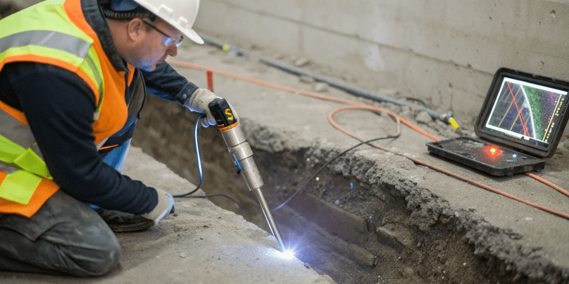
Ground-Penetrating Radar (GPR)
So, what about the utilities that EM can’t see? For non-conductive lines like PVC, concrete storm drains, or fiber optic cables, we turn to Ground-Penetrating Radar (GPR). A GPR unit works by sending high-frequency radio waves into the ground. When these waves encounter a buried object or a change in soil density, they reflect back to a receiver, creating a real-time digital image of the subsurface. This technology is essential for finding non-metallic targets and other buried anomalies that EM locating would otherwise miss. With GPR scanning, we can create a much more complete map of your site, revealing everything from unmarked pipes and old foundations to underground storage tanks and soil disturbances.
Passive Locating Methods
In some situations, we can’t make a direct connection to a utility to apply an active signal. That’s when we use passive locating methods. Instead of transmitting our own signal, our equipment is set to "listen" for frequencies that are already present in the ground. Live electrical lines, for instance, naturally radiate an electromagnetic field that our receivers can detect and trace without any direct connection. This makes passive locating a critical first step for identifying immediate electrical hazards on any job site. It can also detect signals from telephone lines, cable TV, and even radio frequencies that have been re-radiated by other nearby metallic utilities, adding another layer of safety and discovery to our investigation.
Mapping Your Data with GPS and GIS
Finding utilities is only half the battle. To make that information truly useful for your project, we need to map it with precision. Temporary paint and flags are helpful on-site, but they fade, get moved, or are destroyed over time. We use high-precision GPS and GIS (Geographic Information System) technology to capture the exact coordinates of every located utility. This data is then processed to create detailed, georeferenced maps of your site’s subsurface. Instead of a temporary visual, you get a permanent digital record that can be overlaid onto your own CAD files, site plans, and design documents. This GPS and GIS mapping ensures your entire team has reliable data for planning, design, and future reference.
Creating a 3D View of Your Site
For complex sites with congested utility corridors, a flat 2D map might not tell the whole story. By combining all the data gathered from EM, GPR, and GPS, we can create a 3D model of your subsurface infrastructure. This provides an unparalleled view of how different utilities cross, stack, and interact with each other at various depths. A 3D visualization helps project managers and engineers understand these complex spatial relationships, making it far easier to plan deep excavations, directional boring, or new installations without causing a utility strike. It’s the clearest way to see exactly what you’re working with before you commit to breaking ground, preventing costly conflicts and redesigns down the road.
Plan Your Project for Clear Results
A successful utility locate isn’t just about showing up with advanced equipment. The best results come from smart planning. When you know what you're looking for and what challenges your site might present, you set the stage for a fast, accurate, and useful survey. Think of it as creating a game plan before the team even steps onto the field. This preparation helps us choose the right tools, focus our search, and deliver the clear, actionable data you need to move your project forward safely. A little bit of prep work upfront saves a massive amount of time, money, and potential headaches down the road. It’s the difference between a wild guess and a confident decision. From assessing the ground conditions to defining your final report, every step matters. Let's walk through how to plan your project to ensure you get the clean, engineer-ready results your team can depend on.
Assess Your Site Conditions
Start with what you know. Any existing maps, as-builts, or site plans—even if they’re old—provide a valuable starting point. Over time, records of underground utilities can become inaccurate, but they still offer important clues. A quick site walk can also reveal visual evidence like valve boxes, manholes, or utility markers that help piece the puzzle together. Sharing this information with your locating team gives them a head start. It helps us understand the site’s history and anticipate what we might find, turning a blind search into a targeted investigation. This initial assessment is a crucial first step in our utility locating services.
Consider Depth and Material Type
Not all utilities are created equal. A fiber optic line buried a few feet down requires a different approach than a deep-set concrete storm drain. The material of the utility is just as important. Metallic pipes like copper or ductile iron can be traced with electromagnetic (EM) equipment, but non-metallic lines like PVC or asbestos cement are invisible to it. This is why understanding the potential depth and material type is so critical. It directly influences which technology will be most effective, ensuring we don't miss a critical asset just because we used the wrong tool for the job.
Choose the Right Technology
Once you have an idea of your site conditions and utility types, you can select the right tools. The two workhorses of private utility locating are Ground-Penetrating Radar (GPR) and Electromagnetic (EM) locating. EM is perfect for tracing conductive utilities like power lines and metal pipes. GPR, on the other hand, acts like a high-tech fish-finder for the ground, detecting both metallic and non-metallic objects. Choosing the right technology—or combination of technologies—is key to an efficient and accurate scan. It ensures we can find what 811 misses and give you a complete picture of your subsurface.
Why Using Multiple Methods Works Best
Relying on a single technology can leave you with blind spots. EM locating is fantastic for conductive lines but can’t see plastic pipes. GPR can find non-metallic targets but can be limited by certain soil conditions. This is why using multiple methods is the gold standard. By combining the strengths of GPR and EM, we can cross-reference findings and confirm the location of utilities with much higher confidence. This layered approach addresses the limitations of each individual technique and is fundamental to creating a reliable subsurface utility mapping of your entire site. It’s the most effective way to reduce risk and avoid surprises.
Know Your Documentation Needs
What do you need to do with the data once the scan is complete? The answer determines the final deliverable. If you just need to clear a small area for a soil boring, painted marks on the ground might be enough. But if you’re planning a major site expansion, you’ll likely need a detailed digital map. Clear documentation is essential for safety, compliance, and future planning. We can provide everything from simple sketches to precise GPS & GIS mapping data that integrates directly into your engineering designs. Knowing your documentation needs from the start ensures the final product is exactly what your team requires.
Best Practices for Field Operations
Getting accurate subsurface data isn’t just about having the latest equipment—it’s about having a solid game plan. A systematic approach in the field is what separates a clean, reliable map from a confusing mess of marks. Every project is different, but the core principles of a successful locate remain the same: start with what you know, use the right tools for the job, and verify everything.
Following a consistent process ensures that nothing gets missed. It starts with a thorough site review and moves methodically through detection, marking, and quality control. This structured workflow helps our crews deliver the clear, field-ready data you need to keep your project safe and on schedule. It also allows us to adapt to unexpected site conditions without sacrificing accuracy. By sticking to these best practices, we can confidently identify and map underground utilities, giving your team the information it needs to dig without worry.
Starting with a Site Survey
Before any equipment is turned on, the first step is a comprehensive site survey. This initial phase involves gathering all available information to build a preliminary picture of the underground environment. Our crews start by reviewing existing maps, as-builts, and utility plans to understand what’s supposed to be there. Then, we conduct a thorough site walk to identify visible clues on the surface. This includes looking for manholes, valve boxes, utility risers, and old markings from previous locates. This groundwork helps us form a hypothesis about where utilities might be, creating a more efficient and targeted plan for the electronic detection phase.
The Step-by-Step Detection Process
Once we have a baseline from the site survey, we begin the active detection process. Using tools like electromagnetic (EM) locators and ground-penetrating radar (GPR), our technicians systematically sweep the project area in a grid pattern. This methodical approach ensures complete coverage and helps pinpoint the location of buried lines. As each utility is detected, it is immediately marked on the ground with paint or flags according to industry-standard color codes. This provides a clear visual guide for your excavation team, showing them exactly where they need to be cautious. The process is repeated until all potential utilities within the scope of work have been identified and marked.
How We Ensure Quality Control
To make sure our data is reliable, we follow the industry-standard framework for Subsurface Utility Engineering (SUE). This system uses four distinct Quality Levels (QL) to define the accuracy and completeness of utility information. These levels range from QL-D (relying on existing records) to QL-A (confirming the exact location and depth through visual exposure). By classifying data according to these standards, we provide a clear understanding of its reliability. This allows you to make informed decisions based on your project’s specific risks and requirements, ensuring you have the right level of confidence before breaking ground.
Understanding Standard Utility Markings
The colorful lines painted on the ground at a job site are more than just decoration—they’re a universal language. Each color represents a specific type of utility, helping everyone on site understand what lies beneath. For example, red indicates electric lines, yellow is for gas or oil, blue signifies potable water, and orange is used for communications lines like fiber optics. These marks show the approximate horizontal location of a utility. For projects requiring the highest level of accuracy (QL-A), we can expose a small portion of the utility to visually confirm its precise horizontal and vertical position, material type, and size.
Working Around Environmental Factors
No two job sites are the same, and our crews are trained to handle a wide range of environmental challenges. Factors like soil composition, moisture levels, and surface obstructions can all impact the effectiveness of our equipment. For instance, non-conductive pipes made of plastic or concrete cannot be traced with a standard electromagnetic locator. In these situations, we rely on ground-penetrating radar to get a clear picture. Highly congested areas with multiple overlapping utilities also require a careful, multi-technology approach. Our experienced technicians know how to interpret complex signals and adjust their methods to overcome these obstacles, ensuring accurate results even in the toughest conditions.
Handling Common Locating Challenges
Even with the best technology, utility locating is rarely a simple point-and-scan job. Every site comes with its own history and unique conditions that can complicate the process. From dense urban environments with layers of overlapping utilities to rural sites with no records at all, our crews have seen it all. The key isn't just having the right tools—it's having the field experience to know how to handle these challenges when they pop up.
An expert technician knows how to interpret faint signals, work around surface obstructions, and adapt their strategy to changing ground conditions. This ability to problem-solve on the fly is what separates a basic locate from a truly reliable site map. It’s about combining technology with critical thinking to deliver a clear and accurate picture of what’s happening underground, no matter the obstacles.
Overcoming Obstacles in the Field
One of the biggest hurdles in private utility locating is working with incomplete or inaccurate records. As-built drawings are often outdated, and on older properties, they may not exist at all. Relying solely on these documents is a major risk. Utilities may have been moved, abandoned, or added without ever being recorded. That’s why our process always starts with a fresh investigation. We treat the site as a blank slate and use our equipment to build a new, accurate map from the ground up, verifying every signal instead of just confirming what a piece of paper says.
Understanding Technology Limitations
There is no single piece of equipment that can find every type of utility in every condition. Each tool has its strengths and weaknesses. For example, electromagnetic (EM) locators are fantastic for finding conductive pipes and cables, but they can’t detect non-metallic lines like PVC or concrete. That’s where Ground-Penetrating Radar (GPR) comes in, as it can identify both metallic and non-metallic objects. An experienced team understands these limitations and knows that the best approach is to use multiple technologies to get a complete picture and ensure nothing gets missed.
How Weather and Soil Affect Scans
The ground itself can be a major challenge. Soil composition, moisture levels, and even temperature can impact how well locating equipment works. Highly conductive soils, like dense clay, can make it difficult for GPR signals to penetrate deeply, while very dry, sandy soil might provide a much clearer picture. Heavy rain can saturate the ground and interfere with signals, just as frozen ground can. Our field crews are trained to assess these environmental factors on-site and adjust their equipment settings and techniques to compensate, ensuring we get the most accurate data possible regardless of the conditions.
Strategies for Managing Risk
Ultimately, utility locating is all about risk management. Every unknown utility is a potential hazard that can lead to dangerous accidents, expensive repairs, and significant project delays. The most effective strategy for managing this risk is to get the most complete and accurate data before you ever break ground. By creating a detailed subsurface utility map, you can plan your excavation, trenching, or boring with confidence. This proactive approach turns unknowns into knowns, allowing your team to work safely and efficiently while protecting critical infrastructure.
How We Verify Accuracy
We never rely on a single reading. Accuracy comes from a process of cross-verification. Our crews use a combination of GPR, EM locating, and passive methods to detect and confirm each utility. If an EM locator picks up a conductive line, we use GPR to verify its depth and see if any non-metallic lines are running alongside it. We then use GPS and GIS mapping to plot these verified findings onto a digital map. This multi-layered approach ensures that every mark on the ground is backed by multiple data points, giving you a final deliverable you can trust.
Frequently Asked Questions
Why do I need a private locate if I’ve already called 811? Think of 811 as the first step, not the final one. The free 811 service only requires public utility companies to mark the lines they own, and their responsibility stops at your property line or meter. All the infrastructure beyond that point—like the power lines running between buildings, water lines for fire hydrants, or communication cables on your property—is considered private. We specialize in finding and mapping this private infrastructure to give you a complete picture of your entire job site.
Which SUE Quality Level is right for my project? The right Quality Level really depends on the risk involved in your work. For early-stage design or general site planning, a Quality Level B (QL-B) locate is typically what you need. This involves using geophysical equipment like GPR and EM to determine the horizontal path of buried utilities. However, if you’re planning to excavate right next to a critical gas line or need to tie into an existing sewer pipe, you’ll need Quality Level A (QL-A). This is the highest level of accuracy, where we physically expose the utility to verify its exact depth and location.
What happens if my site has no existing utility maps or records? That’s a very common situation, and it’s exactly why a physical investigation is so critical. Outdated or non-existent records are a major liability. We approach these sites by building a new, accurate map from the ground up. Our process relies on the real-time data we gather with our equipment, not on potentially flawed paperwork. We use our tools to find what’s actually there, giving you a reliable picture of the subsurface regardless of the site's history.
How long does the utility locating process typically take? The timeline for a locate depends entirely on the size and complexity of the area you need scanned. Clearing a small, open patch of land for a few soil borings might only take a couple of hours. A large, active industrial site with dense, overlapping utilities could take several days to map thoroughly. Once we understand the scope of your project, we can provide a much more specific time estimate.
What do I receive after the locate is finished? Our final deliverable is tailored to what your project requires. For straightforward clearing tasks, we provide clear, color-coded paint and flags on the ground that your field crew can easily follow. For more complex engineering or design projects, we deliver detailed digital maps created with high-precision GPS. These files can be integrated directly into your CAD or GIS software, giving your entire team a permanent and accurate record of your site’s underground infrastructure.