
Understanding GPR Scanning: A Beginner's Guide
Think of it like a high-tech stud finder for the ground. When you want to hang a heavy picture, you don’t just start drilling holes in the wall; you use a tool to find the solid structure behind the drywall. Ground Penetrating Radar works on a similar principle, but on a much larger scale. It sends a signal into the ground or concrete to find what’s hidden beneath the surface without causing any damage. For project managers and general contractors, gpr scanning is the essential step that locates rebar, conduits, and both metallic and non-metallic utility lines. It replaces guesswork with a reliable map, ensuring your team can dig, drill, or cut with confidence. Here’s what you need to know about how this technology works.
Key Takeaways
Treat GPR as risk management, not an expense: A proactive scan prevents costly utility strikes and project delays by replacing subsurface guesswork with a reliable, data-driven plan.
Hire the expert, not just the equipment: GPR data is a series of complex signals, not a simple picture. The accuracy of your results depends entirely on the technician's skill in interpreting that data.
Site conditions determine scan quality: GPR is not an all-seeing X-ray. Its effectiveness is influenced by factors like soil type and moisture, which a professional technician accounts for to deliver the most accurate results possible.
What Is Ground Penetrating Radar (GPR)?
Think of Ground Penetrating Radar (GPR) as a high-tech way to see what’s hidden underground or inside concrete without having to break anything open. It’s a non-destructive method that gives you a clear picture of the subsurface, helping you find utilities, rebar, voids, and other objects before you ever start digging or drilling.
Instead of guessing what lies beneath, GPR provides a reliable map of buried infrastructure. This process allows our expert crews to deliver fast, field-ready results, so you can avoid costly surprises and keep your project on schedule. For internal structural assessments, rely on our professional concrete scanning services.
How Does GPR Technology Work?
At its core, GPR operates by sending tiny pulses of radar energy into a surface. When these waves travel through the ground or concrete, they hit objects with different properties—like a PVC pipe in soil or rebar in a concrete slab. As the waves encounter these objects, some of the energy bounces back to a receiving antenna on the surface. A trained technician monitors these returning signals on a screen, where they often appear as unique shapes called hyperbolas. By analyzing the shape, size, and location of these reflections, an expert can identify the object, its depth, and its precise location. This real-time analysis is crucial for accurate subsurface utility mapping and ensures you have actionable data right when you need it.
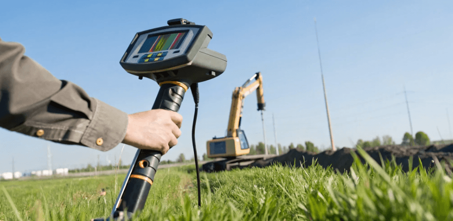
The Core Parts of a GPR System
A typical GPR system is made up of three main components that work together to gather subsurface data. While the technology is complex, the hardware itself is designed for efficient fieldwork.
Control Unit: This is the brain of the operation. It contains a computer that generates the radar pulses sent by the antenna and records the data that comes back. This is where the technician views the scan results in real time.
Antenna: The antenna is the part that does the heavy lifting. It sends the radar waves into the ground and receives the reflected signals. Different antennas are used for different depths and resolutions, allowing us to tailor the scan to your project’s specific needs.
Power Supply: A portable power source, usually a rechargeable battery pack, keeps the system running in the field without needing access to a standard outlet.
Why GPR is Safe and Non-Destructive
One of the biggest advantages of GPR is that it’s completely safe and non-invasive. The entire process is done from the surface, so there’s no need for disruptive digging or drilling just to investigate an area. This makes it an ideal choice for active facilities, busy public spaces, and environmentally sensitive sites. The technology uses a very low-power radio signal—less than what your cell phone emits—and does not involve any harmful radiation, unlike X-ray methods. GPR is also quiet, so it won’t disturb ongoing work or nearby tenants. When you need to find underground utilities or inspect concrete, our utility locating services use GPR to give you answers without disturbing your site.
Where You'll See GPR in Action
Ground penetrating radar is much more than a niche tool; it’s a versatile technology used across construction, environmental, and engineering fields. You’ll find GPR crews on active construction sites, investigating potential environmental hazards, and assessing the health of existing infrastructure. Because it’s a non-destructive method, GPR allows teams to see what’s hidden inside concrete or buried underground without having to break ground or cause any damage. This ability to gather critical data beforehand makes projects safer and more efficient. From mapping utilities before an excavation to checking the integrity of a concrete slab, GPR provides the clear, actionable insights needed to move forward with confidence.
Locating and Mapping Utilities
One of the most common uses for GPR is finding and mapping underground utilities. Before you dig, trench, or drill, you need to know what’s below the surface. GPR is excellent at detecting variations in the ground, which makes it possible to identify both metallic and non-metallic pipes, cables, and conduits that traditional methods might miss. This includes PVC, fiber optic lines, and even older clay pipes. An experienced technician can use GPR to create a detailed map of the subsurface, showing the location and depth of buried assets. This information is essential for any site development or repair project, as it helps you avoid dangerous and costly utility strikes. The data gathered provides a clear plan for safe excavation and construction.
Analyzing Concrete Structures
GPR is also an indispensable tool for safely working with concrete. Before you cut, core, or drill into a concrete slab, wall, or column, you need to know what’s embedded inside. GPR sends radio waves into the structure, which bounce off any objects they encounter. A trained analyst reads these signals to pinpoint the location of rebar, post-tension cables, and electrical conduits. This process of concrete scanning prevents you from compromising the structural integrity of the concrete or hitting a live electrical line. It’s a critical safety step that protects both your crew and your project timeline by avoiding expensive damage and dangerous accidents.
Conducting Environmental Surveys
Environmental consultants and engineers frequently rely on GPR for site assessments. The technology is highly effective for locating buried objects like underground storage tanks (USTs), septic systems, and old drums without disturbing the soil. GPR can also help map soil stratigraphy, identify the bedrock depth, and detect potential contaminant plumes. This is especially useful for Phase II Environmental Site Assessments, where you need to investigate potential subsurface contamination. By providing a clear picture of what lies beneath, GPR helps teams make informed decisions about remediation and site management, all while minimizing the environmental impact of the investigation itself.
Assessing Infrastructure Health
Beyond new construction, GPR plays a key role in maintaining the health of existing infrastructure. Engineers use it to inspect bridge decks, parking garages, tunnels, and building foundations. The scans can reveal voids beneath slabs, detect areas of deterioration or delamination within concrete, and verify the placement and spacing of rebar. GPR can even be used on vertical surfaces like walls and columns to map out internal components. This type of non-destructive evaluation helps facility managers and engineers identify potential problems early, allowing them to plan for repairs and maintenance before a minor issue becomes a major structural failure.
Why Use GPR for Your Project?
When you’re managing a construction or excavation project, the last thing you need are surprises buried underground. Ground penetrating radar moves your project from guesswork to a data-driven plan. It’s a proactive step that gives you a clear picture of what’s happening beneath the surface before you ever break ground. Think of it as an essential risk management tool that protects your timeline, your budget, and your crew.
By investing in a GPR scan upfront, you’re not just locating utilities; you’re building a foundation of certainty. This technology allows you to identify potential conflicts, verify as-built drawings, and make informed decisions with confidence. Whether you’re trenching for new fiber, planning soil borings, or cutting into a concrete slab, GPR provides the critical intelligence needed to keep your project moving forward safely and efficiently. It’s about replacing the unknown with actionable information you can trust.
Prevent Costly Utility Strikes
Drilling or cutting into concrethttps://sitetwin.store/mapping-the-underground/-utility-locating-servicese without knowing what’s inside is a major gamble. A single mistake can lead to hitting rebar, post-tension cables, or live electrical conduits, causing serious injuries, structural damage, and expensive delays. GPR helps you safely cut, core, and drill by precisely locating these hidden elements before they become a problem. A thorough scan maps out the subsurface, giving your team a clear path to work.
This isn't just about avoiding damage; it's about protecting your bottom line and schedule. An unexpected utility strike can shut down a job site for days or even weeks, leading to costly repairs and project overruns. By using GPR to locate utilities first, you prevent these accidents from happening, ensuring your project stays on track and your crew stays safe.
Investigate Without Disturbing the Site
One of the biggest advantages of GPR is that it’s a completely non-destructive investigation method. Unlike exploratory digging or using X-rays, GPR scanning doesn’t damage property or expose anyone to harmful radiation. The equipment is quiet, portable, and emits no disruptive signals, meaning work can often continue nearby without interruption. This is especially valuable on active job sites or in sensitive environments where minimizing disturbance is a top priority.
Because GPR is non-invasive, you can gather extensive data across a large area quickly and cleanly. There’s no need for costly and time-consuming excavation just to see what’s there. The process is efficient and leaves the site exactly as it was found, providing you with the critical information you need without creating more work for your team.
Get Real-Time, Actionable Data
GPR delivers immediate results you can use right away. As the technician scans the area, the data appears on the screen in real time. Our expert crews can interpret this information on the spot, marking the location of rebar, conduits, and utilities directly onto the concrete or ground surface. This gives your field team the clear, visual guidance they need to proceed with their work safely and without hesitation.
Beyond the immediate field markings, the data collected is used to create detailed reports and maps. We can produce clear 2D plans and even 3D models that provide a comprehensive view of the subsurface. This level of subsurface utility mapping is invaluable for project planning, design, and creating accurate as-built records for future reference, ensuring everyone is working from the same reliable information.
Plan Your Project with Confidence
Ultimately, GPR gives you the confidence to execute your project plan without worrying about costly surprises. It’s smart to use GPR before any excavation deeper than 18 inches or before cutting into any concrete structure. Knowing the precise location and depth of buried infrastructure allows you to design around obstacles, avoid clashes, and create a more efficient and realistic project schedule from the start.
This foresight helps prevent the kind of last-minute change orders that can derail a project’s budget and timeline. When you and your stakeholders have a clear, verified map of the subsurface, you can move forward decisively. You’re no longer reacting to problems as they appear—you’re proactively managing the site with a complete understanding of the conditions.
What Affects GPR Accuracy?
Ground penetrating radar is an incredibly powerful tool, but it’s not an x-ray machine that sees perfectly through everything. The clarity and accuracy of a GPR scan depend heavily on the conditions at your site. An experienced technician knows how to read these conditions and adjust their approach, but it’s helpful for you to know what variables are at play.
Understanding these factors helps you set realistic expectations and appreciate why a professional site assessment is so important before the scan even begins. From the type of soil to the depth of the target, several key elements determine the quality of the data we can collect. When you hire a professional crew, you’re not just paying for the equipment; you’re paying for the expertise to interpret how these on-site conditions influence the results and deliver a clear, actionable map of what’s underground.
How Soil and Moisture Impact Scans
Think of a GPR signal like a flashlight beam. In clear air, the beam travels far and illuminates objects clearly. But if you shine it through foggy or murky water, the light scatters and doesn't penetrate as deeply. Soil and moisture work the same way on radar waves. The effectiveness of a GPR scan is directly influenced by soil moisture content and the presence of high-conductivity materials like clay or salt. Wet, clay-heavy soils absorb and disperse the radar signal, making it difficult to detect deeper targets. Dry, sandy soil, on the other hand, is ideal for GPR as it allows the radar waves to travel much farther with minimal interference.
The Properties of Buried Materials
A common misconception is that GPR can find any buried object. In reality, GPR works by detecting the difference between a target and its surrounding material. The bigger the contrast in electrical properties, the stronger and clearer the reflection. For example, a metal pipe buried in sandy soil creates a very strong, easy-to-spot signal. However, a plastic pipe in wet clay might be much harder to distinguish because its properties are more similar to the surrounding soil. This is why identifying non-metallic lines requires specialized expertise and the right equipment settings to perform accurate utility locating services.
Target Depth vs. Scan Resolution
GPR antennas come in different frequencies, and there’s a direct trade-off between how deep you can see and how much detail you can capture. Higher-frequency antennas provide incredible detail and high-resolution images, making them perfect for locating shallow targets like rebar in a concrete slab. The downside is their signal doesn't travel very deep. Lower-frequency antennas are the opposite; their signals penetrate much deeper into the ground, allowing us to find utilities buried several feet down. However, they provide a lower-resolution image, making it harder to distinguish small or closely spaced targets. A skilled technician will often use multiple antennas to create a complete subsurface utility map.
On-Site Environmental Factors
Beyond soil and target properties, other factors at your site can affect GPR data quality. Dense reinforcement like rebar or wire mesh in concrete can create a lot of signal reflection, sometimes masking deeper targets. Above-ground obstructions like buildings, vehicles, or dense vegetation can limit where the equipment can physically go, creating gaps in the data. Even strong radio frequency interference from nearby cell towers or power lines can introduce noise into the scan. An experienced crew knows how to identify these potential issues during the initial site walk and adapt their scanning strategy to minimize their impact on the final results.
How to Read GPR Results
A GPR scan doesn’t produce a simple photograph of what’s underground. The raw data looks more like a series of waves and arcs on a screen, which requires a trained eye to decipher. Think of it like a medical ultrasound—the technician knows how to interpret the shapes and shadows to see what’s really there. Understanding the basics of how this data is read helps you appreciate what goes into a final, accurate utility map.
The process moves from collecting raw signals in the field to creating a clear, actionable report you can use for project planning. An experienced technician analyzes the data at every step, filtering out noise and identifying the distinct signatures of buried utilities, rebar, or other subsurface features. This interpretation is where expertise makes all the difference, turning complex radar signals into a reliable map of your site. To ensure you receive the most accurate data, rely on our expert GPR scanning services for your next project.
Making Sense of the Scan Data
When the GPR unit sends radio waves into the ground, they bounce off any object they encounter. This reflected signal creates a distinct shape on the technician’s screen called a hyperbola—an upside-down "U." The size, shape, and clarity of this hyperbola provide clues about the object's depth, size, and material type. A sharp, clear hyperbola might indicate a metallic pipe, while a weaker one could suggest a plastic conduit or a change in soil layers. A skilled technician reads these signals in real-time, piecing together a preliminary picture of the subsurface landscape as they scan the area.
Understanding Data Formats and Outputs
A single GPR scan only provides a 2D slice of the ground. To create a complete picture, technicians perform multiple scans in a grid pattern. Specialized software then stitches these individual slices together, creating a 3D data block. From there, the analyst can generate "depth slices," which are horizontal, top-down views of the site at different depths. This allows them to see the layout of utilities as if they were looking down from above, making it much easier to trace lines, identify crossings, and understand the overall underground environment before you ever break ground.
Turning Scans into Digital Maps
The real value for your project comes when this interpreted data is transformed into a clear, usable map. After analyzing the hyperbolas and depth slices, technicians translate the findings into CAD drawings or GIS files. These subsurface utility maps overlay the location and depth of all detected features onto a site plan. For complex projects, this information can even be integrated into 3D BIM models, giving engineers and architects a complete view of both above-ground and below-ground structures. This final deliverable is what turns raw data into a powerful planning tool.
Analyzing the Final Report
The final report is more than just a map; it’s a comprehensive summary of the GPR survey. It should detail the equipment used, the site conditions, and any limitations encountered during the scan. For example, high soil moisture or clay content can sometimes affect signal penetration, and the report should note this. A professional GPR provider will explain their findings clearly, ensuring you understand what was located and have confidence in the results. This complete analysis is crucial for making informed decisions and ensuring your utility locating efforts support a safe and efficient project.
The GPR Scanning Process, Step-by-Step
Getting accurate GPR results isn’t as simple as just rolling a machine across the ground. A professional scan is a methodical process designed to deliver clear, reliable data you can build on. From understanding your project goals to creating a final map, every step is crucial for a successful outcome. Here’s a look at how our expert crews approach each project to ensure nothing is left to chance.
Step 1: The Initial Site Assessment
Before any equipment comes out, the first step is a thorough site assessment. This is where we align the GPR strategy with your project’s specific goals. Are you clearing a path for a new fiber line, planning soil borings, or trying to identify unknown objects? We’ll analyze the surface conditions, review any existing site plans, and discuss known utilities or potential obstructions. As experts at US Radar note, it's vital to "thoughtfully analyze your target" and properly configure the system from the start. This initial planning ensures we use the right frequency antenna and approach for our utility locating services, saving you time and preventing surprises down the road.
Step 2: Planning the Survey
Once we understand the site and your objectives, we map out a precise survey plan. This usually involves establishing a grid pattern over the target area. A systematic grid ensures we get complete coverage and don’t miss anything hiding between scan lines. The complexity of the grid depends on the job. For example, a project needing to map utilities across a large area requires a different approach than one focused on locating rebar within a concrete slab.
This detailed planning is the foundation for the fieldwork that follows and is key to collecting the high-quality data needed for accurate subsurface utility mapping. For professional ground penetrating radar utility locating, we follow this rigorous process to ensure every detail is documented.
Step 3: Collecting Data in the Field
This is the part of the process where the technician is actively scanning your site. As our crew moves the GPR unit across the pre-planned grid, the system sends radio waves into the ground. When these waves hit an object—like a pipe, conduit, or void—they bounce back to the receiver. This creates a signal that appears as a distinct shape, often a hyperbola, on the technician’s screen. A trained expert can interpret these signals in real-time to identify the location and approximate depth of buried targets, marking their findings on the surface as they go for immediate reference.
Step 4: Analysis and Reporting
After the fieldwork is complete, the raw scan data is transferred to specialized software for post-processing and analysis. Here, we assemble the individual scan lines into a cohesive view of the subsurface. This software allows us to create "depth slices," which are essentially horizontal cross-sections that show a top-down view of everything buried at specific depths. The final step is turning this complex data into a clear, actionable report. Instead of raw data, you receive clean, engineer-ready results, like a digital map or CAD file from our GPS & GIS mapping services, that you can use to move your project forward with confidence.
Common Myths About GPR
Ground penetrating radar is an incredibly powerful tool, but it’s also one of the most misunderstood technologies in the field. When you know what GPR can and can’t do, you can plan your project more effectively and make better decisions with the data you receive. Let’s clear the air and walk through some of the most common myths about GPR so you can approach your next project with confidence.
Expectations vs. Reality on Accuracy
One of the biggest misconceptions about GPR is that it produces a clear, X-ray-like picture of everything underground. Many people expect to see a perfect image of a pipe or conduit, but that’s not how the technology works. The GPR screen displays raw data as a series of lines, curves, and contrasting shades—not a photograph. These patterns, often called hyperbolas, represent reflections from subsurface objects. An experienced technician interprets these reflections to identify the location, depth, and potential type of a buried utility or anomaly. The final result is an accurate map, but the process is one of expert data interpretation, not simple image viewing.
The Skill Behind Operating the Equipment
It’s easy to assume that anyone can grab a GPR unit and start scanning, but the equipment is only as good as the person operating it. Getting clean, actionable data requires more than just pushing a cart across a site. A trained professional knows how to calibrate the machine for specific soil conditions, select the right antenna frequency for the target depth, and recognize the subtle patterns that distinguish a utility line from a rock or tree root. The real skill is in the interpretation. Our expert field crews spend years learning to analyze raw data in real-time, filter out background noise, and translate those squiggly lines into a clear, reliable map of the subsurface.
Breaking Down the True Cost
Some project managers hesitate to use GPR, believing it’s an unnecessary expense. In reality, the cost of not scanning is almost always higher. The expense of a GPR survey is minimal when compared to the staggering costs of a utility strike, which can include project delays, emergency repairs, hefty fines, and even serious injuries. Think of GPR not as a cost, but as an investment in risk management. Proactively locating underground utilities before you dig is one of the most effective ways to keep your project on schedule, on budget, and most importantly, safe for everyone on site.
Understanding the Technology's Limits
Another common myth is that GPR can penetrate any material to any depth. While it’s incredibly versatile, GPR performance is heavily influenced by site conditions. The radar signal struggles to penetrate dense, conductive materials like clay or soil with high moisture content. In these environments, the signal can weaken quickly, limiting the depth and clarity of the scan. This is why a professional site assessment is so important. An experienced technician will understand these limitations and may use multiple methods, like electromagnetic (EM) locating, to build a complete and accurate subsurface utility map that you can trust.
How to Choose the Right GPR Provider
Not all GPR providers deliver the same quality of results. The technology is powerful, but it’s only as good as the team operating it. Choosing the right partner is the most important step in getting clear, reliable data you can actually use to move your project forward. When you’re vetting a company, you’re not just hiring a piece of equipment; you’re hiring an expert who can interpret complex signals and give you a clear picture of what’s happening underground. A cheap scan that delivers confusing or inaccurate data isn't a bargain—it's a liability that can lead to dangerous utility strikes, costly project delays, and major redesigns.
Making the right choice means less risk, fewer surprises, and a smoother project from start to finish. A true professional partner acts as an extension of your team, providing the critical subsurface intelligence you need to plan with confidence. To make sure you’re working with a company that fits this description, you need to look beyond the price tag and focus on four key areas: their technical skill, the equipment they use, their safety standards, and the support they offer after the scan is complete. Here’s a practical breakdown of what to ask and what to look for.
Verify Their Technical Expertise
The most advanced GPR scanner in the world is useless without a trained technician who can make sense of the data. Interpreting GPR results is a skill that takes significant training and field experience. The screen doesn’t show a perfect picture of a pipe; it shows waves, arches, and reflections that an expert must analyze to identify buried objects. Ask potential providers about their team’s training and certifications. A seasoned crew can distinguish between a utility line, a rock, and other subsurface clutter, which is critical for accurate subsurface utility mapping. Don’t be afraid to ask for case studies or examples of past projects similar to yours.
Ask About Their Equipment and Technology
Technology changes, and you want a provider who invests in modern, high-quality equipment. Ask what specific tools they use for the job. A comprehensive approach often involves more than just one device. For example, a professional crew will typically use a combination of Ground Penetrating Radar (GPR) to find non-metallic lines like PVC and concrete, and Electromagnetic (EM) locators to trace live electrical conduits and other metallic utilities. Using multiple technologies provides a more complete and reliable picture of the subsurface. This ensures they can find what 811 misses and give you the confidence to dig safely.
Check Their Service and Safety Standards
Professionalism and safety should be non-negotiable. First, it’s important to know that GPR technology is completely safe. Unlike X-rays, it doesn’t use harmful radiation, and the process is non-destructive, meaning it won’t disturb the area being scanned. A professional provider will operate with clear safety protocols and be able to explain their process to you and your team. Look for a company that prioritizes clear communication, arrives on time, and works efficiently on your site. You want a partner who respects your project schedule and provides direct contact with their experts, not a call center.
Ensure They Offer Full Project Support
The work isn’t finished once the team leaves your site. The real value is in the final deliverable. What kind of report will you receive? A great provider offers more than just raw data; they give you clear, actionable results. Ask if they provide detailed 2D maps or 3D models that integrate with your project plans. The best utility locating services deliver clean, engineer-ready data that helps you make informed decisions. This level of support turns a simple scan into a powerful planning tool, helping you design around underground obstacles and prevent costly conflicts during construction.
Frequently Asked Questions
I already called 811. Do I still need a GPR scan? Yes, it’s a smart move. The 811 service is essential for locating public utilities, but their records typically stop at your property line. A GPR scan picks up where 811 leaves off by mapping the private utilities that run throughout your site, like water lines between buildings or electrical conduits in a parking lot. It also finds things that public locators don't mark, such as non-metallic pipes, old septic systems, or other unknown objects that could bring your project to a halt.
Can GPR tell me exactly what kind of material a pipe is made of? While GPR is fantastic at pinpointing an object's location and depth, it doesn't provide a material label. An experienced technician can make a highly educated guess based on the strength and shape of the radar reflection. For instance, a metal pipe creates a much different signal than a PVC or concrete one. We often combine GPR with other tools, like an EM locator, to confirm the material type and give you the most accurate information possible.
How deep can GPR actually see underground? The effective depth of a GPR scan depends entirely on the site conditions. In ideal soil, like dry sand, we can often detect targets buried 10-15 feet deep or even more. However, in dense, wet clay, the radar signal doesn't travel as far, so the depth may be much shallower. We always select the right antenna for your specific goals, balancing the need for depth with the level of detail your project requires.
How long does a typical GPR survey take to complete? The time it takes depends on the size and complexity of the area you need scanned. A simple scan to locate rebar in a small concrete slab might only take an hour or two. Mapping out all the utilities across a large commercial property could take a full day or more. We always start with a site assessment to understand your project scope and give you a realistic timeline before we begin any work.
Will the GPR scan interfere with our operations or sensitive equipment on site? Not at all. GPR is a completely safe and non-invasive technology. The equipment uses a very low-power radio signal—even less than a cell phone—so it won't interfere with sensitive electronics or communications systems. The process is also quiet and doesn't produce any vibrations, which means you can often continue your normal site operations without any disruption while we work.