
What Is Utility Potholing? Your Guide to Site Safety
One of the most dangerous assumptions on a job site is that calling 811 is all you need to do to dig safely. Public locators only mark public utilities, leaving a huge information gap for any private lines running across your property. To fill that gap, you need a private utility locator and a method for absolute verification. This is where potholing becomes essential. So, what is utility potholing? It is the only process that provides 100% certainty by creating a small test hole to physically confirm a utility’s location and depth, ensuring there are no surprises when excavation begins.
Key Takeaways
- Go beyond surface marks: Potholing provides the ground truth that electronic locators can't, visually confirming the exact depth and position of utilities to prevent dangerous and costly excavation errors.
- It's a precise, skilled process: Professionals use non-destructive methods like vacuum excavation to safely expose utilities. This surgical approach protects buried lines and requires trained operators, not just a shovel.
- Invest in certainty to protect your project: The upfront cost of potholing is a small investment compared to the massive financial and scheduling setbacks from a single utility strike. It's essential insurance for your budget and timeline.
What Is Utility Potholing?
Before you break ground, you need to know exactly what lies beneath the surface. While utility maps and markings give you a good idea, they don’t provide the certainty needed to dig safely. That’s where utility potholing comes in. It’s a crucial step for verifying the precise horizontal and vertical location of underground lines, protecting your crew, your budget, and your timeline from the consequences of a utility strike. Think of it as the final, definitive check that turns a line on a drawing into a known quantity in the field.
What It Is and Why It Matters
Utility potholing, also known as daylighting, is an excavation method that uses small, targeted test holes to physically expose underground utilities. Instead of guessing, your crew gets visual confirmation of a pipe or conduit’s exact depth and position. This process is fundamental to damage prevention. Hitting a gas line, water main, or fiber optic cable can lead to dangerous accidents, expensive repairs, and significant project delays. Potholing removes that risk by providing the ground-truth data needed to dig with confidence, ensuring your project stays on schedule and within budget.
Common Project Applications
Potholing is a standard practice for almost any construction or maintenance project that involves digging. It’s essential when planning for soil borings, trenching for new electrical or communication lines, or preparing a site for a new foundation. You’ll also find it used for smaller-scale jobs, like installing new telephone poles, street signs, or fences where excavation is required near known utilities. Any time your team needs to break ground safely, potholing provides the necessary verification to move forward without guesswork.
Key Safety and Compliance Rules
Because potholing involves excavation, safety is the top priority. Professional crews must follow strict protocols to prevent injuries and ensure site stability. This means adhering to all OSHA guidelines for excavation, which cover everything from trench safety to soil management. Furthermore, every team member should be thoroughly trained on the equipment they’re using and fully aware of all on-site safety procedures. Compliance isn’t just about following rules; it’s about creating a secure work environment where everyone understands the risks and knows how to manage them effectively.
How Potholing Protects Your Project
Ultimately, potholing is an investment in your project’s success. It’s the most reliable way to prevent a utility strike, protecting your assets and your team. While potholing is the final step in verification, the process becomes much more efficient when you start with high-quality data. Accurate private utility locating and subsurface mapping can pinpoint target areas with greater precision, reducing the number of test holes required. This saves you time and money while still delivering the certainty you need to proceed safely.
A Look at Potholing Methods and Technology
Once you know potholing is necessary, the next step is choosing the right method. The goal is always the same: to visually confirm a utility’s location with minimal disturbance. Modern techniques have made this process safer and more precise than ever, moving far beyond risky mechanical digging. The method your crew uses will depend on soil conditions, project scope, and the type of utilities you’re dealing with. Combining these techniques with advanced locating tools like GPR ensures your team has a complete picture of the subsurface before breaking ground. Let's walk through the most common methods and the technology that supports them.
Vacuum Excavation
Think of vacuum excavation as the industry standard for safely and precisely exposing buried utilities. This non-destructive method uses a powerful vacuum to remove soil, virtually eliminating the risk of damaging a line with a shovel or backhoe. It’s a critical step in any modern utility locating service because it provides definitive proof of a utility's depth and position. By combining vacuum excavation with tools like GPR, professionals can create an accurate, field-verified map of underground infrastructure. This approach ensures that when excavation begins, your crew is working with confirmed data, not guesswork, preventing costly strikes and project delays.
Hydro Excavation
Hydro excavation is a popular form of vacuum excavation that uses high-pressure water to break up soil. Once the soil is turned into a slurry, a powerful vacuum truck sucks it up and stores it in a debris tank. This method is incredibly effective and often faster than other techniques, especially in compacted or frozen ground. While it requires specialized equipment and water access, it’s considered one of the safest ways to dig around sensitive infrastructure like fiber optic cables or gas lines. The precision of the water jet allows crews to carefully work around targets without causing damage, making it a go-to choice for congested utility corridors.
Air Excavation
Air excavation works on the same principle as hydro excavation, but it uses compressed air instead of water to loosen the soil. A high-pressure air stream fractures the ground, and a vacuum hose removes the dry debris. This method is particularly useful in softer soils or on job sites where water is a concern—for example, around electrical conduits or in areas with strict environmental regulations. A key advantage is that the excavated soil (spoil) is dry and can often be used immediately for backfilling the hole. This saves time and reduces costs associated with hauling away wet slurry and bringing in new fill material.
Ground Penetrating Radar (GPR)
Before you even start digging, Ground Penetrating Radar (GPR) can give you a look beneath the surface. This technology sends radio waves into the ground and reads the signals that bounce back to create a map of what’s below. GPR is fantastic for identifying both metallic and non-metallic lines—like PVC or concrete pipes—that other locators might miss. Using GPR for subsurface utility mapping before potholing helps crews create a more accurate plan, pinpointing the exact locations to excavate. This reduces the number of holes needed, saving you time and money while increasing overall site safety.
The Right Tools for the Job
Ultimately, the success of any potholing operation comes down to two things: the right equipment and a well-trained crew. Using a hydro-vac truck or an air excavation system requires skill and a deep understanding of safety protocols. The equipment must be regularly inspected and maintained to ensure it functions correctly and safely on site. More importantly, the operators need to be thoroughly trained on how to handle the machinery, interpret utility markings, and respond to unexpected situations. A professional team knows that the tools are only as good as the people using them, which is why ongoing training and a commitment to safety are non-negotiable.
The Potholing Process from Start to Finish
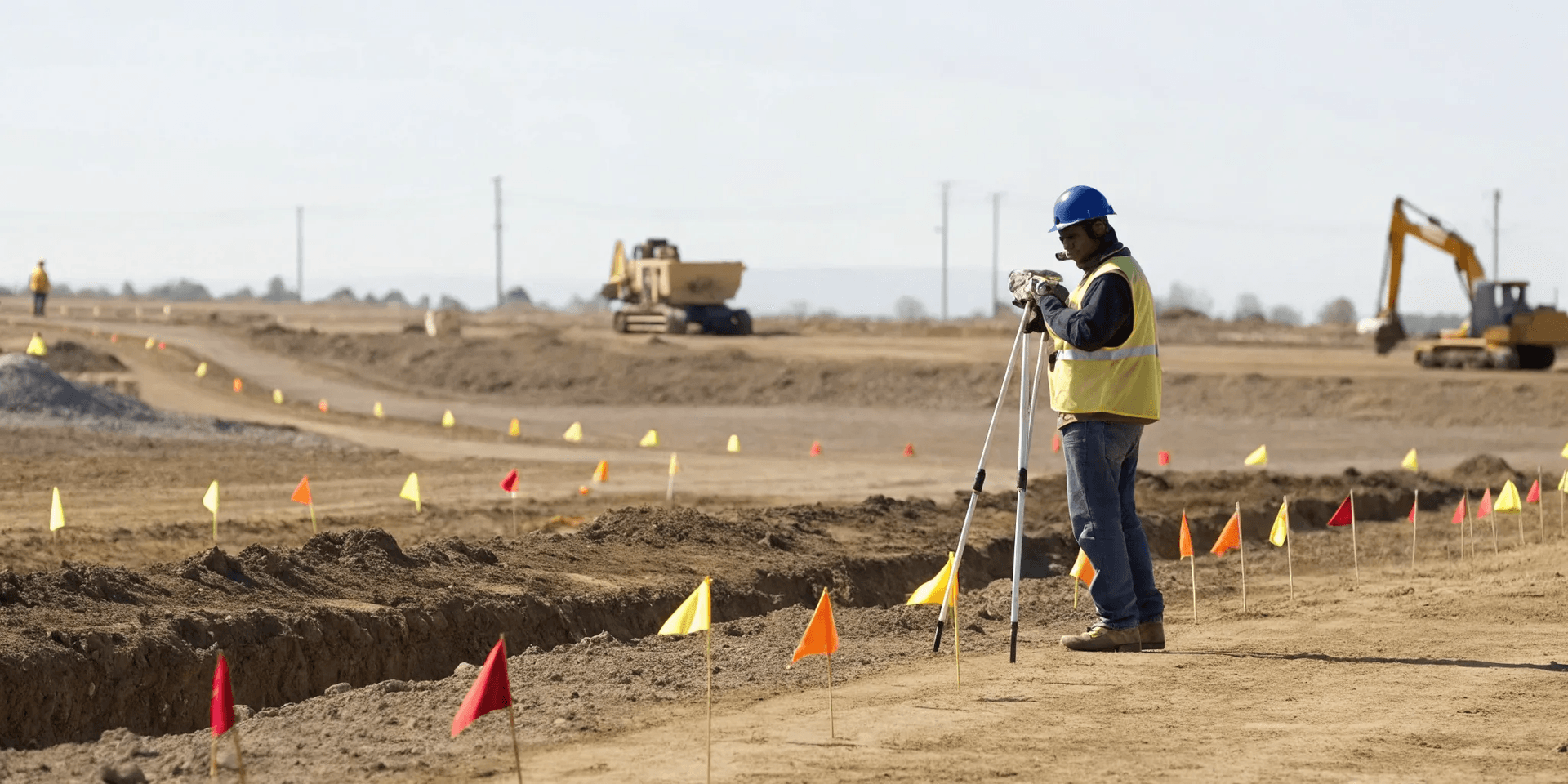
Potholing isn’t just about digging a hole; it’s a systematic process that turns uncertainty into solid data. Each step is designed to safely and accurately confirm the exact location of underground utilities, giving your team the confidence to break ground. Think of it as a surgical procedure for your job site—precise, planned, and focused on a successful outcome. From initial planning to final restoration, a professional crew follows a clear workflow to protect your assets, your people, and your schedule. This methodical approach eliminates the guesswork that often leads to dangerous utility strikes and costly project delays. By breaking the process down, you can see how each action builds upon the last to create a complete and reliable picture of the subsurface environment. It’s about replacing assumptions with facts, ensuring that when your heavy equipment arrives, you know exactly what’s down there and where it is. This level of certainty is the foundation of any safe and efficient excavation project.
Step 1: Assess the Site
Before any soil is moved, the crew does its homework. This initial phase is all about planning and preparation. Technicians start by reviewing any available utility maps, as-builts, and public records to get a preliminary idea of what lies beneath the surface. They also handle the logistics of securing any necessary permits to work in the area. Based on this information and a physical site walk-down, they develop a strategic plan for where to pothole. This ensures that every test hole is placed for maximum effect, answering the critical questions your project depends on without unnecessary disturbance to the site. It’s a crucial first step that sets the entire operation up for success.
Step 2: Mark and Document Utilities
With a plan in place, the next step is to pinpoint the approximate location of the buried lines. Crews use geophysical tools like electromagnetic (EM) locators and ground penetrating radar to trace the utilities. Once they have a confident mark, they use paint or flags to show the location on the surface. This is where our private utility locating services create the initial roadmap for the physical verification to come. After the utility is visually identified in the next step, technicians meticulously document its horizontal and vertical position, depth, size, and material. This information is critical for creating accurate site plans and ensuring safe excavation for everyone involved on the project.
Step 3: Perform the Excavation
This is where we get visual confirmation. Instead of using a backhoe or shovel, which could easily damage a utility, crews use vacuum excavation. This technique uses either high-pressure water (hydro excavation) or air (air excavation) to safely loosen the soil, which is then immediately suctioned into a debris tank. The result is a small, clean hole—typically 6 to 12 inches in diameter—that extends directly down to the utility. This non-destructive method allows the crew to safely expose the line without risking a costly and dangerous strike. It provides a clear, unobstructed window to the infrastructure below so there are no surprises when real digging begins.
Step 4: Ensure Quality Control
Once the utility is exposed, the team performs a quality check. This is the moment of truth where the data from the initial scan is physically verified. The crew confirms the utility’s material (like PVC, copper, or fiber), measures its exact depth from the surface, and assesses its general condition. This verified information is then used to create or update a subsurface utility map, providing an accurate, field-verified record for engineers and excavation teams. Following strict safety protocols during this step is essential to protect both the crew and the critical infrastructure they are working around. This step turns a simple mark on the ground into reliable, actionable data.
Step 5: Restore the Work Area
A professional job isn’t finished until the site is put back together. After all the necessary data has been collected, the crew carefully backfills the test hole. This is more than just shoveling dirt back in; the soil is typically replaced and compacted in layers to prevent it from settling over time, which could create a safety hazard or a sinkhole. The surface is then restored to its original condition, whether that means replacing sod, patching asphalt, or pouring new concrete. The goal is to leave the work area looking as if no one was ever there, ensuring the site is safe, stable, and ready for the next phase of your project.
Safety First: Potholing Best Practices
Potholing is an incredibly precise and safe method for verifying underground utilities, but its effectiveness hinges on a commitment to safety. Cutting corners isn't an option when you're working around active utility lines. A safe project is a successful project, which means every step—from crew training to site cleanup—should be guided by clear, established best practices. These protocols protect your crew, your project timeline, and your budget from the fallout of an accidental utility strike. By prioritizing safety, you ensure that potholing delivers the accurate data you need without introducing unnecessary risks to the job site.
Proper Crew Training and Certification
You wouldn’t hand over the controls of complex machinery to an amateur, and the same goes for potholing equipment. A well-trained crew is your first line of defense against accidents. Every team member should be thoroughly trained on the specific vacuum excavator or hydro excavator they’re using, as well as the proper safety procedures for the job site. This includes understanding how to read utility maps, recognize signs of different utility types, and operate equipment safely around them. Regular equipment maintenance and checks are also critical to ensure everything functions correctly. Investing in a team with proven utility locating expertise means you’re getting professionals who know the technology and the protocols inside and out.
Essential Personal Protective Equipment (PPE)
Personal Protective Equipment (PPE) is non-negotiable on any excavation site. It’s the essential gear that protects your crew from potential hazards. Every worker involved in the potholing process must be outfitted with the right equipment, including hard hats, steel-toed boots, high-visibility vests, safety glasses, and gloves. Depending on the site conditions, additional gear like hearing protection or respiratory masks might be necessary. Having a comprehensive safety plan is key, and that plan starts with ensuring everyone is properly equipped before work begins. Following OSHA guidelines for excavation provides a solid framework for keeping your team safe from trenching-related dangers and other on-site risks.
Clear On-Site Communication
Even the best-laid plans can fall apart without clear communication. On a busy job site, every crew member needs to be on the same page. This starts with a pre-excavation briefing or "toolbox talk" to review the day's plan, identify potential hazards, and confirm everyone’s roles. Workers must adhere to strict safety protocols, using established hand signals and maintaining clear lines of sight with equipment operators. Effective on-site communication ensures that if conditions change or an unexpected obstacle appears, the entire team can react quickly and safely. It’s this constant dialogue that turns a group of individuals into a cohesive, safety-focused unit.
Emergency Response Planning
No one wants an emergency to happen, but everyone should be prepared for one. A detailed emergency response plan is a critical part of any potholing project. Before the first bit of soil is moved, your team should know exactly what to do if a utility line is struck. This plan should include emergency contact numbers for utility companies, local emergency services, and project managers. It should also specify the location of first-aid kits and fire extinguishers and outline evacuation procedures. Having a clear, rehearsed plan ensures a calm, swift, and effective response, minimizing potential damage and keeping everyone safe.
Environmental Protection Measures
Potholing is valued for its precision, which also makes it an environmentally responsible choice for utility verification. Unlike disruptive open-trenching, methods like vacuum excavation create minimal disturbance to the surrounding area. This investigative method exposes underground utilities with a much smaller footprint, preserving topsoil and nearby vegetation. A key part of the process is proper site restoration. Once the utility has been verified, the hole is carefully backfilled and compacted to restore the ground to its original condition. This commitment to subsurface utility mapping with minimal impact protects both your project and the environment.
Common Myths About Utility Potholing
When it comes to excavation, what you don’t know can definitely hurt you. Misconceptions about utility locating and potholing are common, but they can lead to dangerous utility strikes, costly project delays, and serious injuries. Believing these myths puts your crew, your budget, and your timeline at risk. Let's clear the air and debunk a few of the most persistent myths so you can plan your next project with confidence and keep your site safe.
Myth #1: "811 marks all my utilities."
This is one of the most dangerous assumptions in excavation. The 811 "Call Before You Dig" service is an essential first step, but it's just that—a first step. Public utility companies will only mark the lines they own and operate, typically from the main line to your meter. They will not locate any private utilities on your property. This includes power lines running to a security gate, water lines for an irrigation system, or fiber optic cables connecting two buildings. To find these, you need private utility locating services that can identify everything lurking beneath the surface.
Myth #2: "It's only for massive projects."
Potholing isn't reserved for huge commercial developments or sprawling industrial sites. The reality is that any excavation, no matter the size, carries the risk of hitting a buried utility. Whether you're planning a single soil boring, trenching for a new data line, or installing a small foundation, potholing provides the precise location and depth of nearby utilities. It’s a scalable safety measure that protects every project, preventing a small job from turning into a massive headache. The goal is always to dig safely, and potholing is a key part of that process.
Myth #3: "All utilities are buried at a standard depth."
Never assume a utility is at a "standard" depth. Over time, the ground surface changes. Landscaping, erosion, and new layers of pavement can alter the grade, making a once-deep utility much shallower than you'd expect. Plus, older lines may have been installed before modern codes were even established. Depth estimates from locating equipment are just that—estimates. Potholing is the only way to get visual confirmation of a utility's exact depth, ensuring your excavation plan is based on facts, not guesswork. This is a critical step in creating an accurate subsurface utility map.
Myth #4: "The technology finds everything, every time."
Ground penetrating radar (GPR) and electromagnetic (EM) locators are incredibly powerful tools, but they have limitations. Dense clay soils, high water tables, and congested underground areas can interfere with signals and make it difficult to get a clear reading. Non-metallic pipes like PVC or concrete can also be challenging to detect. That’s why potholing is so important—it serves as the physical proof that confirms what the technology suggests. It’s the final quality control step that turns a confident guess into absolute certainty before the excavator bucket ever touches the ground.
Myth #5: "It's just digging a hole—how hard can it be?"
Potholing is a surgical procedure, not a shoveling free-for-all. It’s a precise, non-destructive method that requires trained technicians and specialized equipment. Professionals use tools like hydro or air vacuum excavators to carefully remove soil without damaging the utility's casing or coating. This investigative method is designed to safely expose buried assets for visual identification. Trying to do it with a shovel or backhoe is a recipe for a utility strike. It’s a skilled process that protects the very infrastructure you’re trying to work around, ensuring both safety and integrity.
Breaking Down Potholing Costs and ROI
When you’re managing a project budget, every line item counts. Potholing is an investment in safety and certainty, and understanding its cost and return is key. While it might seem like an extra step, the cost of not potholing can be exponentially higher, leading to dangerous accidents, costly repairs, and significant project delays. Think of it as insurance for your excavation work—a small upfront cost that protects you from catastrophic losses down the road.
The real value of potholing isn't just in the holes you dig; it's in the strikes you prevent, the schedules you keep, and the safety you guarantee for your crew and the public. It’s about replacing assumptions with facts so you can dig with confidence. Let's break down what goes into the cost and why it’s one of the smartest investments you can make for your site.
What Factors Influence the Cost?
Potholing isn’t a one-price-fits-all service. The final cost depends on several key factors specific to your project. A professional crew will assess the number of holes needed to verify utility locations, as well as their required depth and diameter. Site logistics also play a big role. For instance, the accessibility of a water source for hydro excavation and the distance to an approved disposal site for the excavated soil can influence the time and resources required. A clear scope of work allows a private utility locating firm to provide an accurate, transparent quote tailored to your exact needs.
The ROI of Preventing Utility Strikes
The return on investment for potholing becomes crystal clear when you consider the alternative. Hitting a single utility line can bring a project to a screeching halt. The costs aren't just for the immediate repair; they include crew downtime, project delays, potential fines, and damage to your company's reputation. Imagine a fiber optic cable strike that cuts off service to a business district or a water main break that floods your site. The expense of fixing these damages far outweighs the preventative cost of potholing. It’s a proactive measure that protects your budget from unexpected and devastating financial hits.
How Potholing Helps You Stay Compliant
Beyond the practical benefits, potholing is often a matter of compliance. In many jurisdictions, regulations require you to visually confirm the location of underground utilities before you begin any mechanical digging. This process, known as daylighting, is a critical part of safe excavation protocols. Failing to do so can result in steep fines and legal liability if an accident occurs. By incorporating potholing into your pre-excavation workflow, you’re not just ensuring safety—you’re performing the necessary due diligence to keep your project compliant and avoid regulatory penalties.
Getting a Clear Quote for Your Project
To get a reliable price for your project, a contractor needs to consider all the variables we've discussed. At SiteTwin, we don’t use call centers or one-size-fits-all pricing. We work with you to understand your project’s unique requirements, from the number of test holes to the site conditions. This allows us to provide a clear, detailed quote with no surprises. When you’re ready to secure your site and move forward with confidence, our team can deliver the field-ready data you need. You can contact us directly to discuss your project and get a quote from our experts.
Frequently Asked Questions
Isn't calling 811 enough before I dig? Calling 811 is an essential first step, but it only covers public utilities—the lines that run from the main to your meter. Any private lines on your property, like power to an outbuilding, irrigation systems, or data cables between buildings, won't be marked. Private locating and potholing fill in these critical gaps, giving you a complete picture of everything underground so you can protect your entire site.
Do I still need potholing if you use GPR first? Yes, the two services work together perfectly. Think of Ground Penetrating Radar (GPR) as the X-ray that shows us where utilities are located. Potholing is the follow-up visual confirmation. It allows us to physically see the utility, verify its exact depth and material, and confirm the GPR data is accurate. Using GPR first makes the potholing process smarter and more efficient by telling us exactly where to dig.
When should I choose hydro excavation versus air excavation? The best method depends on your site conditions. Hydro excavation uses high-pressure water and is extremely effective in tough, compacted, or frozen soil. Air excavation uses compressed air, which is ideal when working near sensitive electrical utilities or in areas where introducing water is a concern. A major benefit of air excavation is that the soil removed is dry and can often be used immediately to backfill the hole.
How many test holes will my project need? The number of holes depends entirely on your project's scope and what you need to verify. We typically focus on critical points where your planned excavation path will cross existing utilities. By starting with a thorough private utility locate, we can create a strategic plan that minimizes the number of holes while still providing the absolute certainty you need to proceed safely.
What happens right after the utility is exposed? Once we have a clear view of the line, our crew documents all the critical details. We measure its precise depth from the surface, confirm its size and material, and capture its exact GPS coordinates. This information provides the "ground truth" needed for accurate site plans. After we've collected the data, we carefully backfill the hole and restore the surface to its original condition.