
Underground Utility Locating for Construction Projects

Construction crews do not get paid to stand around waiting on utility answers. A trench route is laid out. Equipment is scheduled. The operator is ready. Then the crew finds incomplete marks, outdated drawings, unknown utility crossings, or private lines that were never shown on the plans.
That is where underground utility locating becomes part of the construction workflow.
Before trenching, boring, drilling, grading, saw cutting, or excavation, contractors need to know what may be underground and where the highest-risk conflicts are located.
A good utility locate does not eliminate every risk, but it gives the superintendent, project manager, foreman, and excavation crew better field information before work starts.
Why Utility Locating Matters on Construction Sites

Construction projects move fast, and underground conditions are often messy. Plans may be incomplete. As-builts may be old. Utilities may have been rerouted during previous work. Abandoned lines may still be in place. Private utilities may cross the work area without showing up on public records.
That creates risk for:
- Trenching
- Directional boring
- Excavation
- Grading
- Utility tie-ins
- Drainage work
- Sign and fence installation
- Light pole installation
- Building additions
- Parking lot reconstruction
- Concrete cutting and coring
One utility strike can stop production immediately. A damaged water line can flood the trench. A hit fiber line can trigger service outages. A gas or power conflict can create a serious safety issue. Even a smaller private utility can shut down part of a commercial property and delay multiple trades. Utility locating helps reduce that risk before the bucket, bore head, drill, or saw enters the work area.
Start With 811, Then Check for Private Utilities
811 should be contacted before excavation where required. It is the public utility notification process that allows participating utility owners to mark infrastructure they own near the proposed excavation area.
But 811 is not the same as a full private utility investigation. Public utility owners typically mark only their own facilities. On private property, many utilities may belong to the property owner, tenant, facility, developer, or contractor. Those utilities may not be marked through 811.
Private utilities can include:
- Parking lot lighting circuits
- Irrigation lines
- Private water lines
- Private gas lines
- Fire lines
- Secondary electric feeds
- Communication conduit
- Fiber lines
- Security gate power
- Storm or sanitary laterals
- Utilities between buildings
- Abandoned utilities left underground
That does not mean 811 failed. It means 811 and private utility locating serve different purposes. For construction projects on commercial, industrial, multifamily, campus, or private property sites, private locating should be considered when the work area may contain owner-installed or undocumented utilities.
How Underground Utility Locating Works

Utility locating starts with the scope. The technician needs to know the proposed excavation route, bore path, trench limits, scan area, or construction activity being planned.
Useful information includes:
- Project address
- Proposed work area
- Drawings or as-builts
- Site photos
- Known utility records
- Access instructions
- Safety requirements
- Site contact information
- Timing needs
The technician then walks the site and looks for surface clues. These may include manholes, valve boxes, meters, cleanouts, handholes, pull boxes, transformers, light poles, irrigation controls, pavement patches, trench scars, and building penetrations. Those features help guide the investigation before locating equipment is used.
Using EM Locating on Construction Projects
Electromagnetic locating, or EM locating, is commonly used to trace conductive utilities. A technician may connect directly to a utility, clamp onto a cable or conduit, induce a signal from the surface, or use passive methods to detect certain energized or metallic lines.
EM locating may help identify:
- Electric lines
- Metallic water lines
- Communication lines with tracer wire
- Gas lines with tracer wire
- Metallic conduits
- Some private utility corridors
EM locating works best when the utility is conductive, accessible, and able to carry a signal. It can be limited by non-conductive pipe, missing tracer wire, broken tracer wire, poor grounding, inaccessible connection points, signal bleed, and congested utility corridors. That is why construction utility investigations often require more than one method.
Using GPR Scanning for Unknown Utilities
Ground penetrating radar can help investigate subsurface targets that may not be traceable with EM locating alone.
SiteTwin | GPR Scanning Services
GPR scanning may help identify buried targets, utility corridors, trench lines, abandoned utilities, voids, and other anomalies within the scan area. It is useful when records are incomplete, utilities are non-conductive, tracer wire is missing, or the excavation route crosses an unknown area.
GPR has limitations. Soil type, moisture, clay content, depth, surface conditions, debris, utility material, and nearby interference can affect what can be detected. GPR does not guarantee that every underground utility will be found. The best results usually come from combining site records, visual inspection, EM locating, GPR scanning, field markings, and potholing where needed.
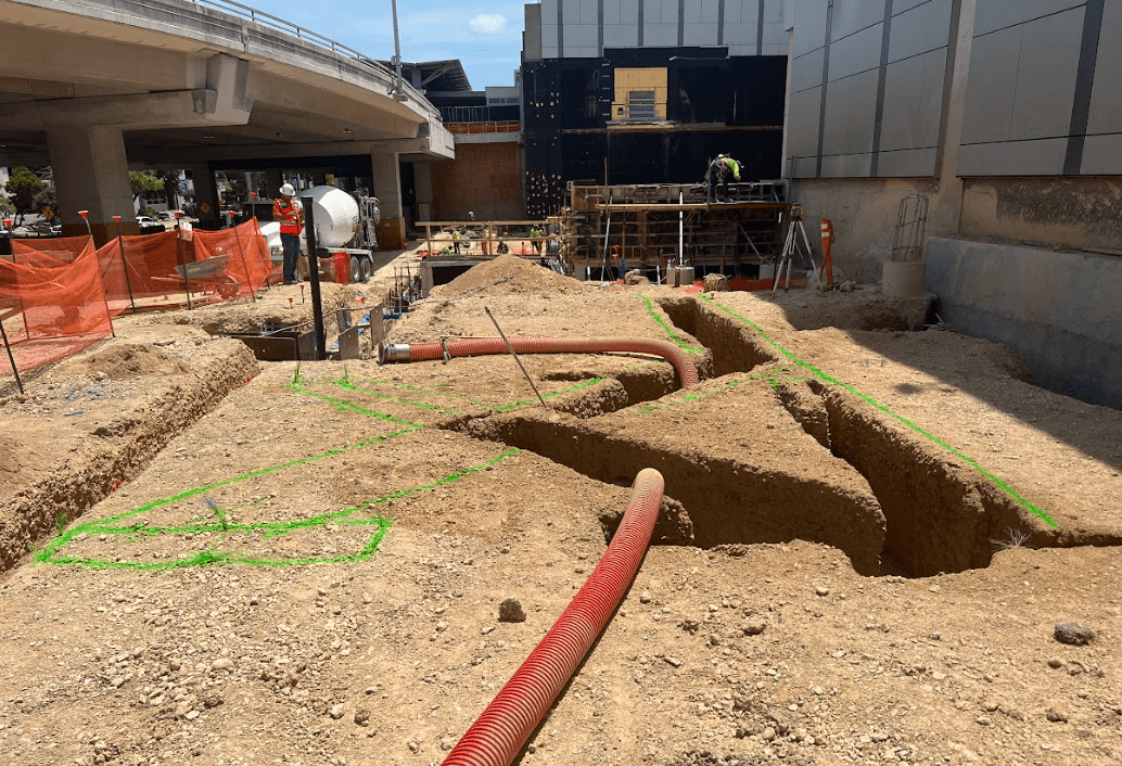
Marking Utilities in the Field
After utilities or suspected targets are identified, they are marked onsite. Depending on site requirements, markings may include paint, flags, stakes, labels, photos, or field notes.
Marks may show:
- Confirmed utility paths
- Suspected utility paths
- Unknown targets
- Conflict areas
- Abandoned utility routes
- Utility corridors
- Areas with limited confidence
- Areas needing potholing
Clear communication is important. A confirmed utility trace is different from a suspected GPR target or an area with poor signal quality. Field markings should help the crew understand where risk exists and where verification is needed before digging.
Potholing Before High-Risk Excavation

Utility locating reduces risk, but it does not replace physical verification. When excavation risk is high, potholing or daylighting should be used to confirm utility depth, location, and type before mechanical excavation continues through a conflict area.
This is especially important before directional boring, deep trenching, utility tie-ins, gas or power conflicts, fiber crossings, water main work, and congested utility corridors.
Surface paint shows the suspected horizontal path. Potholing confirms what is actually underground. A utility may be shallower than expected, deeper than shown, offset from the mark, abandoned, active, or crossing the trench at an angle. Physical verification gives the crew better information before production continues.
Concrete Scanning for Construction Projects
Some construction conflicts are inside concrete, not soil. Before coring, saw cutting, anchoring, or trenching through a slab, concrete scanning may be needed to identify embedded targets.
SiteTwin | Concrete Scanning Services
Concrete scanning can help locate rebar, post-tension cables, conduits, embedded utilities, and unknown objects. It can also help locate voids under concrete before coring or cutting. Post-tension slabs require extra caution because damaging a tendon can create serious safety and repair issues. Concrete scanning also has limitations. Slab thickness, reinforcement density, access, surface conditions, and target depth can affect results.
Utility Mapping and Deliverables
Some construction projects only need paint markings. Others need documentation for the project manager, engineer, owner, or subcontractors. Depending on the scope, SiteTwin may provide:
- Utility paint markings
- Site photos
- Field sketches
- PDF utility maps
- KMZ exports
- GIS-compatible utility mapping
- Conflict notes
- Potholing recommendations
These deliverables are useful when excavation happens later, when multiple trades are involved, or when the project team needs a record of the investigation.
Texas Construction Project Context
Across Texas, construction projects often involve private utilities, old records, and tight schedules.
SiteTwin | Check Out Our Locations
In Houston, Dallas, Austin, San Antonio, and Fort Worth, commercial and industrial properties are frequently expanded, repaired, repaved, and remodeled. That creates utility conditions that may not match the drawings. Underground utility locating helps crews work from field conditions instead of assumptions.
FAQ Section
What is underground utility locating?
Underground utility locating is the process of identifying known and suspected utilities before excavation, trenching, boring, drilling, or construction work.
Does 811 locate all utilities?
No. 811 should be contacted where required, but it usually marks public utility owner infrastructure. Private utilities may require private utility locating.
Can GPR find every underground utility?
No. GPR cannot find every utility in every condition. Soil, moisture, depth, surface conditions, utility material, and congestion can affect results.
When is potholing needed?
Potholing is needed when a utility conflict is high risk or must be physically verified before excavation, trenching, or boring continues.
What should contractors provide before scheduling?
Provide the project address, scope, proposed work area, plans or markups, site photos, access details, schedule needs, and site contact information.
Underground utility locating helps construction crews avoid digging blind.
Before trenching, boring, cutting, drilling, or excavating, get the work area investigated, marked, and documented.